Texas Areas West of I-45 to See Highest Storm Coverage Saturday Afternoon as Scattered Showers Continue Into Early Next Week
TEXAS — A shifting weather pattern is expected to bring scattered showers and thunderstorms across parts of Texas this weekend, with the highest coverage focused west of Interstate 45 on Saturday afternoon. While conditions appear less intense overall, storm activity will still impact parts of the region. Forecasters indicate that this setup will bring periodic rain chances extending into early next week.
Storm Coverage Focused West of I-45 on Saturday
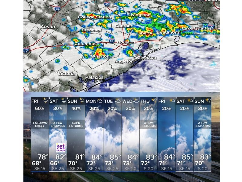
Weather models show that areas west of I-45, including regions near Austin, College Station, and Brenham, will see the greatest concentration of showers and storms during the afternoon hours on Saturday.
Eastern areas, including parts closer to Houston, may still see activity but with lower coverage and more isolated development. This uneven distribution means some communities could see repeated showers while others remain mostly dry.
Conditions Appear Less Intense but Still Active
Compared to previous storm setups, Saturday’s pattern is expected to be less intense overall. However, scattered thunderstorms are still likely, especially during peak heating hours.
These storms are not expected to be widespread or severe in most cases, but brief downpours and lightning remain possible. Residents should remain aware of changing weather conditions throughout the day.
Scattered Storm Chances Continue Into Next Week
Looking beyond the weekend, forecast data suggests that scattered rain chances will persist into early next week. Daily storm chances are expected to remain in the 20 to 40 percent range across much of the region.
This indicates a continued unsettled pattern, with occasional showers and storms developing each day. The exact timing and location of these storms will vary depending on atmospheric conditions.
Localized Downpours Possible With Passing Storms
Even though the overall setup is not expected to be severe, individual storms could still produce brief heavy rainfall. This may lead to localized ponding on roads or minor travel disruptions.
Lightning and gusty winds are also possible with stronger cells. Residents planning outdoor activities should keep an eye on radar trends throughout the day.
Residents Advised to Monitor Changing Conditions
With scattered storms expected over multiple days, officials recommend staying updated on local forecasts and being prepared for brief weather disruptions.
Conditions may shift quickly, especially during the afternoon and evening hours when storm activity is most likely. If you’re seeing storms in your area or experiencing changing weather conditions, share your updates with us at SaludaStandard-Sentinel.com.