Texas and the Southeast Unlikely to See Measurable Snowfall Over Next Two Weeks as Forecast Data Shows Near-Zero Probability
TEXAS — Forecast data covering the next two weeks continues to show no meaningful chance of measurable snowfall across North Central Texas and much of the Southeast, according to the latest probability maps. The data highlights a clear divide between colder regions farther north and areas across the southern tier of the country where snow potential remains extremely low.
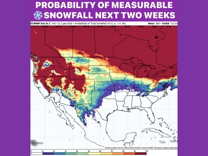
The probability map focuses on the chance of at least one inch of snowfall, and across Texas and neighboring southeastern states, those probabilities remain near zero through the full forecast period. This suggests that even brief or minor winter weather setups are unlikely to produce accumulating snow.
Probability Map Shows Sharp Snowfall Cutoff South of the Midwest
The snowfall probability visualization shows higher chances of measurable snow stretching from parts of the central Plains into the Midwest and Northeast, while probabilities drop off sharply farther south. Large portions of Texas, the Gulf Coast, and the Southeast are shaded in colors indicating little to no snowfall potential.
This sharp gradient reflects a persistent weather pattern keeping colder air locked well north of the region. Without sustained cold air or strong storm systems moving far enough south, snow accumulation remains highly unlikely in these areas.
North Central Texas Remains Outside Snow-Producing Pattern
For North Central Texas, the data shows no signal supportive of measurable snowfall during the next 14 days. While winter systems may pass through parts of the country, the necessary combination of cold temperatures and moisture does not appear to be aligning over the region. Even scenarios that sometimes bring brief wintry mixes appear absent in the current forecast guidance. As a result, residents should not expect snow-related disruptions or winter weather impacts during this period.
Southeast Also Expected to Miss Out on Snow
Across the broader Southeast, including states east of Texas, the probability map similarly reflects minimal snowfall chances. These areas remain firmly within zones where surface temperatures are projected to stay too warm to support accumulating snow. This does not rule out cooler days or passing systems, but the absence of snow probability indicates that winter precipitation will likely fall as rain, if it occurs at all.
What the Forecast Means Going Forward
The extended forecast emphasizes a pattern favoring milder winter conditions across the southern United States. With no measurable snowfall expected, typical winter hazards such as icy roads or snow-covered travel routes are not anticipated across Texas and the Southeast during this timeframe.
However, forecasters note that long-range outlooks can change, especially beyond the two-week window. Still, based on current data, winter weather fans in the region will need to wait longer for any meaningful snow potential to emerge. For now, the takeaway is clear: Texas and the Southeast are not in line for measurable snowfall over the next two weeks, with winter impacts remaining confined to regions farther north.
Continue following updates and long-range outlooks at SaludaStandard-Sentinel.com for the latest weather developments.