Texas and Oklahoma Face Sunday Severe Storm Threat With Tornado, Large Hail and Damaging Wind Risk From Lubbock to Dallas and Wichita Falls
UNITED STATES — A developing severe weather setup is expected to take shape Sunday across parts of Texas and Oklahoma, with conditions favoring tornadoes, large hail, and damaging winds.
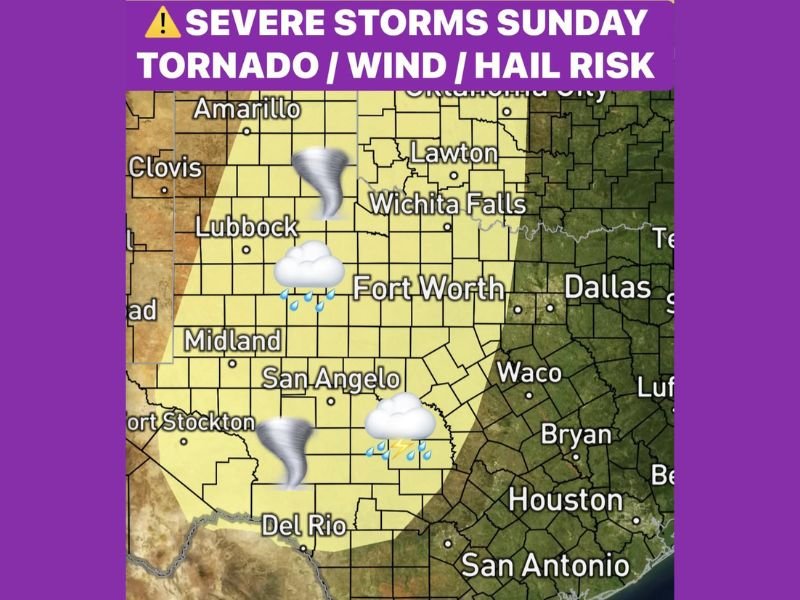
The Storm Prediction Center has already outlined a risk area as an upper-level system approaches from the west, combining with increasing moisture and instability across the region.
Dryline Setup in West Texas Could Trigger Severe Storms
The primary trigger for Sunday’s severe weather will be a dryline setting up across West Texas. This boundary, separating dry air from moist Gulf air, is a common catalyst for strong storm development.
As daytime heating increases, storms are expected to fire along this boundary, particularly in areas near Lubbock, Midland, and San Angelo. These initial storms could quickly become severe, given the favorable atmospheric conditions in place.
Tornado, Hail and Wind Threats All Possible
The setup supports all modes of severe weather, meaning tornadoes, large hail, and damaging winds are all possible.
Supercell thunderstorms may develop, especially during the early stages of storm formation, which increases the likelihood of tornado development in isolated areas.
Large hail and strong wind gusts could also accompany these storms as they intensify and begin moving eastward.
Storms Expected to Move Toward Dallas Fort Worth Region
As storms organize, they are expected to track eastward toward more populated areas, including the Dallas-Fort Worth metroplex.
This progression means that areas initially unaffected in the morning could face severe weather risks later in the day or evening. Residents across North Texas should remain alert as storms approach from the west.
Pattern Could Continue Into Following Week
This severe weather setup may not be limited to just one day. Forecast trends suggest that similar patterns could repeat into the following week.
As the region moves deeper into peak severe weather season, multiple rounds of storms could become more common. This raises the potential for continued severe weather risks across Texas, Oklahoma, and surrounding areas in the days ahead.
What Residents Should Do Ahead of Sunday Storms
With severe weather possible, residents are encouraged to review safety plans and stay updated on forecasts and alerts. Having multiple ways to receive warnings and knowing where to take shelter can be critical during rapidly developing storms. Preparedness is especially important when all hazards, including tornadoes, hail, and wind, are possible.
As Sunday approaches, are you preparing for severe weather in your area? Share your thoughts with us at SaludaStandard-Sentinel.com.