Texas and Oklahoma Face Potent Feb. 13 Storm System With Strong Winds, Thunderstorms, and Backside Snow Risk
OKLAHOMA — A potent storm pattern taking shape over the Central United States is drawing attention ahead of February 13, with forecasters highlighting a deep upper-level trough and strong jet stream energy that often signals a widespread and impactful weather system across states like Texas and Oklahoma.
What Forecasters Are Seeing High Above the Surface
At roughly 18,000 feet (the 500mb level), meteorologists are tracking a deep trough digging into the Central U.S. The red and orange shading shown in model data represents strong atmospheric spin and energy, paired with an active jet stream doing what forecasters describe as “heavy lifting.”
This kind of upper-level setup rarely leads to calm weather and instead favors storm development as it moves east and northeast.
Why Texas Is a Key Part of This Storm’s Development
As the trough digs into Texas, it helps initiate a strengthening surface storm system underneath. This process tightens pressure gradients, which can lead to strong and gusty winds across much of the state.
At the same time, the system is expected to pull Gulf moisture northward, creating a favorable environment for rain and potentially strong thunderstorms on the front side of the storm as it organizes.
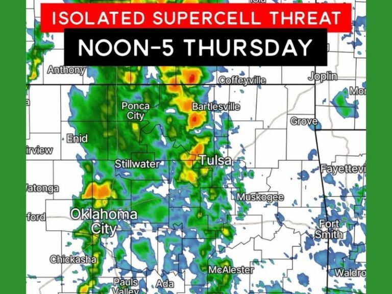
Thunderstorms and Wind Threat Expands Toward Oklahoma
As the system lifts northeast into Oklahoma, forecasters say the combination of lift, moisture, and wind energy could support a more active weather stretch. That may include periods of heavy rain, gusty winds, and thunderstorms as the storm pushes through the region.
This type of tilt and movement is often associated with organized systems that impact a large portion of the country rather than isolated areas.
Snow Potential on the Backside of the System
Once the storm begins lifting out, colder air is expected to wrap in behind it, raising the possibility of snow in parts of the Central Plains. While exact placement will depend on timing and temperature trends, the pattern supports at least some wintry potential on the backside—especially in areas that cool quickly after the main system passes.
What This Pattern Typically Means for Oklahoma
For Oklahoma, setups like this often mean a dynamic and changing weather day, with multiple hazards possible over a short period. Strong winds and storms may be followed by sharply colder conditions, increasing the chance for winter weather impacts depending on how the system evolves.
What concerns you most about this Texas–Oklahoma storm setup—damaging winds, severe thunderstorms, or the chance of snow on the backside? Share what you’re preparing for and follow continuing coverage at SaludaStandard-Sentinel.com.