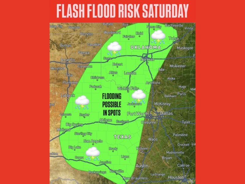
Texas and Oklahoma Face Flash Flood Risk Saturday From Wichita Falls and Abilene to Norman and Tulsa as Heavy Rain Triggers Spot Flooding
TEXAS AND OKLAHOMA — A developing storm system is expected to bring a localized flash flood risk across parts of Texas and Oklahoma on Saturday, with heavy rainfall potentially leading to spot flooding in several areas.
The risk zone stretches from central and western Texas through southern and central Oklahoma, including cities such as Abilene, Wichita Falls, Lawton, Norman, and Tulsa.
Heavy Rain Could Trigger Localized Flooding
Thunderstorms moving through the region are expected to produce periods of heavy rainfall, which could overwhelm drainage systems in some locations.
The primary concern is not widespread flooding, but rather isolated areas where storms repeatedly move over the same location — a process known as “training.” In these areas, rainfall totals can quickly add up, increasing the risk of flash flooding.
Risk Area Covers Parts of Texas and Oklahoma
The highlighted zone includes a broad corridor from western Texas near Midland and San Angelo, extending northeast through Abilene and Wichita Falls into Oklahoma cities such as Lawton, Norman, and Tulsa.
Communities within this area may experience brief but intense downpours capable of causing water to accumulate on roads and low-lying areas. While not everyone in the region will see flooding, those who do could experience rapid changes in conditions.
Recent Rainfall Increases Flood Potential
Another factor contributing to the flood risk is recent rainfall in some parts of the region. Areas that have already seen wet conditions may be more vulnerable to additional rain.
Saturated ground reduces the ability of soil to absorb water, allowing runoff to build more quickly during heavy downpours. This increases the chances of localized flooding, even if overall rainfall totals are not extreme.
Flash Flood Risk Remains Localized but Notable
Despite the concern, the overall flood risk remains relatively low and localized. This means that while flooding is possible, it will likely be limited to specific areas rather than widespread across the entire region.
However, localized flash flooding can still be dangerous, particularly for drivers encountering water-covered roads. Conditions can change rapidly during heavy rainfall, making awareness critical.
Safety Reminder as Storms Develop Saturday
Residents across Texas and Oklahoma are urged to remain cautious, especially when traveling during periods of heavy rain.
If you encounter a flooded roadway, officials advise turning around rather than attempting to drive through water of unknown depth. Staying updated on local weather alerts and monitoring conditions throughout the day will be important as storms develop.
Storm Pattern Continues Across the Region
This flash flood risk is part of a broader active weather pattern expected to impact the region, bringing multiple rounds of storms and shifting conditions. While Saturday’s threat is focused on rainfall and localized flooding, additional storm chances may follow in the coming days.
Residents should stay alert as weather conditions continue to evolve across the Southern Plains. Have you experienced flooding or heavy rain in your area recently? Share your updates with us at SaludaStandard-Sentinel.com and help others stay informed.