Texas and Oklahoma Could Break Temperature Records as “Christmas Torch” Pattern Brings 20–30° Above-Normal Heat Across the Plains
DALLAS, TX — This year’s Christmas forecast for the Southern Plains looks more like early spring than winter, as meteorologists warn of a developing “Christmas Torch” pattern that could push temperatures to record-breaking levels across Texas and Oklahoma between December 23 and 27, 2025.
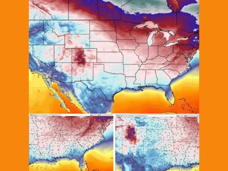
According to new projections from the Climate Prediction Center, a powerful ridge of high pressure will settle over the Great Plains, sending temperatures soaring up to 20–30 degrees above seasonal averages. This pattern could make it one of the warmest Christmas periods on record for several southern and central U.S. states.
Record-Breaking Heat Possible in Texas and Oklahoma
Forecasters say that by Christmas Day, many areas across Dallas, Oklahoma City, and parts of Kansas and Arkansas could experience daytime highs in the mid- to upper-70s, while southern Texas may reach into the low 80s.
“This ridge of high pressure is exceptionally strong for late December,” said one meteorologist tracking the system. “We’re not talking about mild — this is full-on short-sleeve weather for Christmas.”
In Dallas and Fort Worth, temperatures are forecast to hover between 76°F and 79°F, while Oklahoma City could climb into the mid-70s, nearly 25 degrees above average for this time of year.
The last time such warmth occurred during the holiday season was in 2016, when Texas and Oklahoma also saw record highs on Christmas Day.
The “Christmas Torch” Explained
The “Christmas Torch” refers to a massive dome of warm, stable air — known in meteorology as a ridge of high pressure — that traps heat over a large area.
As this ridge expands eastward, it will cover most of the central and southern U.S., extending from New Mexico and Texas all the way to the Midwest and Southeast.
This setup effectively blocks colder Arctic air from moving south, ensuring a snow-free and unusually warm holiday across the Great Plains.
“This is the same kind of upper-atmospheric pattern we see during strong El Niño winters,” explained weather analysts. “It’s deflecting storm systems northward and keeping much of the U.S. unusually mild.”
No White Christmas for the Southern Plains
For many across the region, the possibility of a “White Christmas” is officially off the table. Forecast models show no significant snow or winter weather threats for Texas, Oklahoma, or surrounding states through at least December 27.
Instead, the warmth may push some residents to turn on their air conditioning, as nighttime lows are also projected to remain well above freezing.
“It’s the kind of Christmas where Santa might trade his red suit for shorts,” joked one forecaster.
Impact and Public Reaction
While the warmth may be welcome news for travelers, the early-season heat wave could also bring dryness and elevated fire danger, particularly across western Texas and Oklahoma.
Forecasters are urging caution when using outdoor grills or holiday fireworks due to the increased risk of grass fires in dry, windy areas.
Residents across the Midwest, Deep South, and southern Appalachians will also feel the warmth, with most regions trending 10–20°F above normal through the holiday stretch.
Looking Ahead
The warmth is expected to gradually ease by New Year’s Eve, as the ridge weakens and a more active weather pattern returns across the western and central U.S. However, forecasters say no major Arctic outbreaks are on the horizon before the end of December.
This means much of the central United States will close out 2025 with one of the warmest Christmas weeks in recorded history — a stark contrast to the snowy scenes often associated with the season.
Stay updated with Christmas week forecasts, temperature alerts, and climate updates at SaludaStandard-Sentinel.com.