Texas and Louisiana Face Easter Sunday Severe Storms With Damaging Winds, Intense Lightning and Cold Front Sweeping Toward Mississippi
UNITED STATES — Easter Sunday is bringing an active and potentially disruptive weather setup across parts of the Gulf Coast, with Texas and Louisiana at the center of a developing line of strong storms expected to push east toward Mississippi.
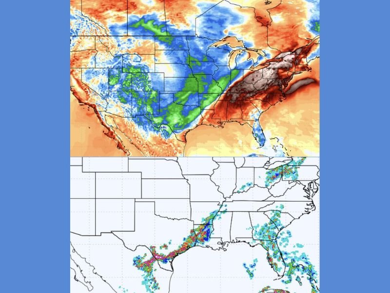
Instead of calm spring conditions, radar trends show storms organizing into a tighter, more intense line capable of producing gusty winds, frequent lightning, and rapidly changing conditions.
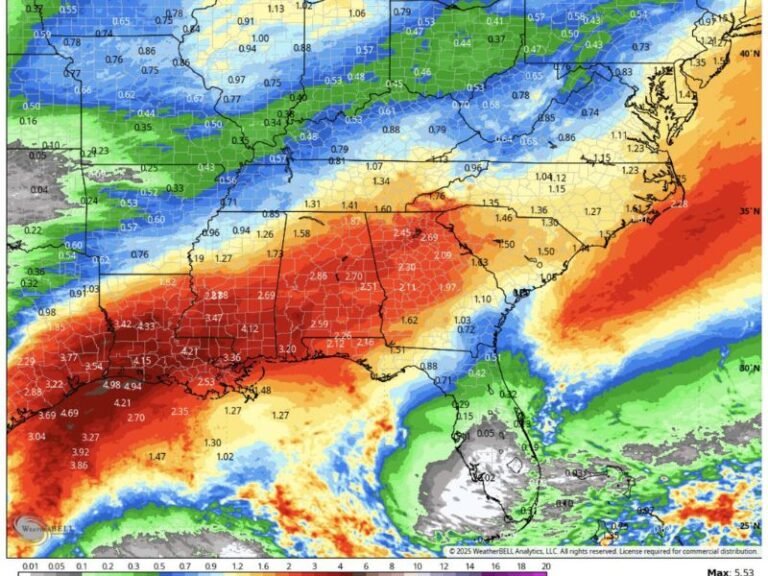
Storm Line Organizing Across Texas and Louisiana
Weather data shows a concentrated line of storms forming over Texas and Louisiana, with activity becoming more organized as it moves eastward. This type of setup often leads to a fast-moving band of thunderstorms that can intensify quickly.
The alignment of storms suggests a continuous line rather than scattered cells, increasing the likelihood of widespread impacts across multiple areas at once.
Communities across eastern Texas and much of Louisiana are likely to experience the first round of strong storms before the system continues into neighboring states.
Damaging Winds and Lightning Expected to Be Primary Threats
The strongest storms within this line could produce wind gusts strong enough to cause minor damage, including downed tree limbs and unsecured outdoor items.
Lightning activity is also expected to be frequent and intense, with storms capable of producing repeated strikes over short periods. This creates dangerous conditions for anyone outdoors, especially during holiday activities.
Heavy rain may accompany these storms, reducing visibility and creating brief travel disruptions in affected areas.
Cold Front Set to Push Storms East Toward Mississippi
Behind the storm line, a cold front is expected to move in, reinforcing the system and pushing it eastward into Mississippi. This transition will likely bring a noticeable shift in temperatures following the storms.
As the front advances, additional areas could see storm activity redevelop or intensify briefly before conditions begin to settle.
The movement of this front will mark the end of the storm threat for Texas and Louisiana but shift the focus farther east.
Easter Plans May Be Impacted Across the Gulf Coast
The timing of these storms on Easter Sunday increases the likelihood of disruptions to outdoor plans, including gatherings, travel, and events.
Conditions may change quickly, with storms developing or intensifying within a short window. Residents are encouraged to remain weather-aware and be prepared to move indoors if storms approach.
Even areas that start the day calm could see deteriorating conditions as the storm line moves through.
Rapid Changes Expected as System Moves Through Region
This setup highlights how quickly spring weather can shift across the Gulf Coast. Warm, unstable air ahead of the system combined with the advancing cold front is creating the ideal environment for strong thunderstorms.
While this does not appear to be a widespread severe outbreak, the storms are still capable of producing localized impacts that should not be ignored.
If you’re in Texas, Louisiana, or Mississippi, share what conditions are like in your area this Easter by visiting SaludaStandard-Sentinel.com.