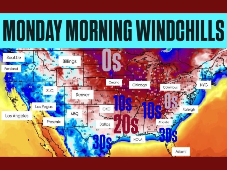
Strong Polar Vortex Over Canada Signals Repeated Cold Shots and Storm Windows Into Mid-February
CANADA — The polar vortex is not collapsing or breaking down, but instead remains strong, organized, and firmly anchored over Canada, a setup that meteorologists say could quietly drive repeated rounds of cold air and winter storm chances across parts of the United States into mid-February.
Rather than a dramatic failure of the vortex, current atmospheric patterns point to a more subtle — and potentially more persistent — influence.
A Stable Vortex Is Locking Arctic Air in Place
When the polar vortex is strong and well-organized, it acts like a lid, keeping the coldest Arctic air bottled up across northern latitudes. In this case, the vortex is spinning steadily over Canada, maintaining its integrity rather than fragmenting or shifting abruptly south.
This stability reduces the likelihood of a single, massive Arctic outbreak, but it does not eliminate winter impacts farther south.
Shortwave Energy Creates “Controlled Leaks” of Cold Air
The key mechanism driving winter weather in this pattern is intermittent shortwave energy, often associated with Rossby waves, moving in from the Pacific. Each time one of these disturbances interacts with the vortex, it can tug just hard enough to pull a lobe of cold air southward.
These controlled leaks open brief windows for surface low development, winter storms, and sharp cold shots — even while the core of the vortex remains intact.
Pattern Mirrors Late January Activity
The same atmospheric configuration that fueled the active weather pattern during the back half of January appears likely to continue. Forecast models suggest this cycle of strong vortex positioning combined with periodic energy intrusions could repeat multiple times into mid-February.
This means colder air is not arriving in one prolonged surge, but instead in waves, each with its own storm potential.
What This Means Going Forward
Rather than signaling a breakdown, this pattern favors repeated winter opportunities. Strong vortex positioning, occasional atmospheric tugs, and frequent cold intrusions increase the chances for additional winter systems to develop when timing and moisture align.
In practical terms, this setup supports continued variability, episodic cold snaps, and ongoing storm chances rather than a quick transition to sustained warmth.
Bottom Line for the Region
The polar vortex remains strong. The Arctic air stays mostly north. But every now and then, the atmosphere finds a way to let some of that cold escape south.
That balance keeps winter very much in play. For continued coverage of evolving winter patterns and what they mean locally, follow updates at SaludaStandard-Sentinel.com.