Strong Cold Front to Bring 40–60 MPH Wind Gusts Across Ohio Monday, With Lakeshore Areas Facing Hazardous Conditions
OHIO — A strong cold front moving in late Sunday night into Monday will generate widespread high winds across Ohio, with gusts expected to reach 40–60 mph and even higher near Lake Erie. Forecasters warn that conditions may deteriorate rapidly behind the front, creating hazardous travel and dangerous marine weather for lakeshore communities.
Widespread 40+ MPH Winds Expected Across the State
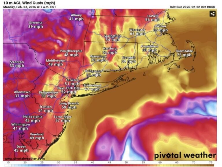
Meteorologists report that much of Ohio will experience 40 mph or stronger wind gusts on Monday, particularly during the morning and midday hours. Areas including Mansfield, Canton, Defiance, Lima, and Columbus are forecast to see gusts between 30 and 50 mph, with blowing debris, scattered power outages, and difficult driving conditions possible. Some northern counties could see isolated gusts closer to 50 mph, especially in open areas and elevated terrain.
Lakeshore Communities Could See 60+ MPH Gusts
Forecasters caution that winds along Lake Erie may reach 60 mph, creating hazardous marine conditions, large waves, and sharply reduced visibility. Certain weather models, including the ECMWF, are even showing the potential for 70 mph winds over the lake, raising concerns for boaters, shoreline infrastructure, and high-profile vehicles traveling near the water.
The combination of strong winds and cold air advection could make conditions feel significantly colder throughout the day.
Cold Front Brings Sharp Shift in Weather
The strong winds will develop quickly behind the advancing cold front early Monday. Temperatures will drop, skies will turn unsettled, and gusty winds will dominate the region until late afternoon. By Monday evening, wind speeds are expected to gradually diminish as colder, more stable air settles into Ohio.
Residents should secure outdoor items, avoid travel during peak wind gusts when possible, and use caution on north–south highways where crosswinds will be strongest. Residents across Ohio are encouraged to stay alert and share local weather impacts at SaludaStandard-Sentinel.com as conditions unfold.