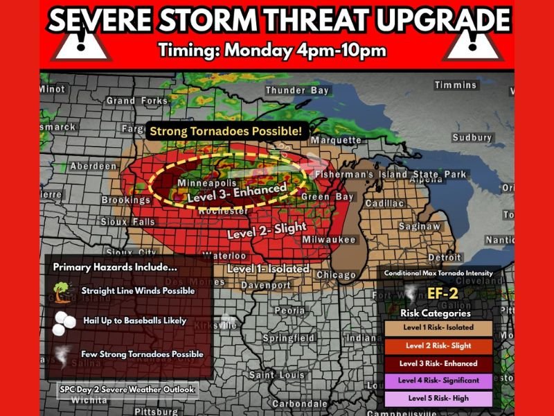
SPC Upgrades Minnesota and Wisconsin to Level 3 Enhanced Risk Monday With Strong Tornadoes, Baseball-Sized Hail and Damaging Winds
MINNESOTA AND WISCONSIN — The Storm Prediction Center has just issued a severe threat upgrade for Monday afternoon and evening across the Upper Midwest, raising the risk to a Level 3 Enhanced severe weather rating for Minnesota and into Wisconsin.
The dangerous window runs from 4 PM through 10 PM, bringing the very real threat of strong tornadoes, baseball-sized hail, and damaging straight line winds. This is not a routine storm day. This is a life-threatening severe weather event that demands immediate preparation from every resident in the affected region.
Level 3 Enhanced Risk Centered on Minneapolis and Surrounding Area
The most dangerous zone on Monday’s upgraded outlook is the Level 3 Enhanced risk area centered directly over Minneapolis and extending into surrounding communities including Rochester and Green Bay. Within this Enhanced zone, the conditional maximum tornado intensity is forecast at EF-2, meaning tornadoes capable of destroying well-built homes and throwing vehicles are possible between 4 PM and 10 PM Monday evening.
A Level 2 Slight risk surrounds the Enhanced zone covering Milwaukee, Waterloo, and areas further south. A Level 1 Isolated risk extends across portions of Iowa, Illinois, and toward the Chicago area.
Three Deadly Hazards Threatening the Region Monday Evening
Three distinct and dangerous hazards are driving the severity of Monday’s upgraded outlook. Strong tornadoes are possible within the Enhanced risk zone, with the EF-2 conditional maximum intensity making this threat one that must be taken with the utmost seriousness by every resident in the area.
Baseball-sized hail is also likely during the peak severe weather window, capable of shattering windows, destroying vehicles, and causing serious injury to anyone caught outdoors. Straight line damaging winds add yet another deadly layer to an already extremely threatening storm setup across the Upper Midwest.
Every Resident Must Be Ready Before 4 PM Monday
Every resident across Minnesota and Wisconsin within the Enhanced and Slight risk zones must have their severe weather plan fully in place before 4 PM Monday arrives. Identify your shelter location now, charge all mobile devices, and ensure your NOAA weather radio is functioning and programmed for your county.
Do not plan any outdoor activities during the 4 PM to 10 PM window. If a tornado warning is issued for your county, move to your lowest interior room immediately and do not wait for visual confirmation before acting.
The time to prepare is right now, not when the sirens start sounding. Stay weather aware and follow updates at SaludaStandard-Sentinel.com.