Southern United States Could See Another Winter Threat as Models Hint at Late-January Ice Potential Across Texas, the Deep South, and the Southeast
UNITED STATES — Winter may not be finished with the South just yet. While no official forecast has been issued, long-range weather model guidance is once again hinting at the possibility of freezing rain and ice potential across parts of Texas, the Lower Mississippi Valley, and the Southeast later in January. Meteorologists stress this is not a forecast or guarantee, but a signal worth monitoring as winter patterns remain active.
What the Long-Range Model Is Showing
The latest GFS long-range guidance, extending toward January 28, displays a broad ribbon of potential freezing rain accumulation stretching from eastern Texas through Louisiana, Mississippi, Alabama, Georgia, and into parts of the Carolinas and Mid-Atlantic.
At this range, the data is considered “fantasy-range”, meaning it can look dramatic without necessarily becoming reality. Still, forecasters note that patterns matter, and the signal suggests winter may still have unfinished business across the southern U.S.
Why Meteorologists Are Paying Attention — But Staying Cautious
Forecasters emphasize several key truths about this setup:
- Timing can shift significantly
- Placement can wobble hundreds of miles
- Ice signals at this range often disappear or evolve
- No impacts are locked in
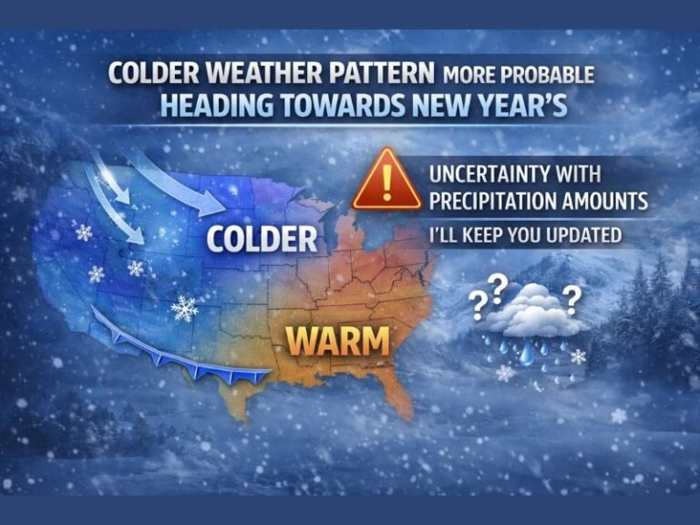
However, the broader pattern — cold air reloading across the eastern U.S. while moisture attempts to return from the Gulf — is one that historically can support ice events in the South under the right conditions.
That combination is why meteorologists are not dismissing the signal outright, even while cautioning against panic or hype.
Why Ice Is the Bigger Concern Than Snow in the South
Unlike snow, freezing rain requires a very specific temperature profile, with cold air near the surface and warmer air aloft. When it happens, even small ice accumulations can cause major problems, including:
- Dangerous travel conditions
- Power outages
- Downed trees and power lines
- School and business disruptions
This is why any ice signal — even weeks out — tends to draw attention across southern states.
What This Does — And Does Not — Mean Right Now
It’s important to be clear:
- This is not a forecast
- This is not a promise
- This does not mean an ice storm is coming
What it does mean is that winter patterns remain active, and additional cold intrusions into the South are still possible before the season fully shuts down.
Meteorologists describe this as winter “side-eyeing” the region, essentially saying: don’t unpack just yet.
What Residents Should Do at This Stage
For now, the guidance calls for awareness, not alarm:
- Stay informed as shorter-range forecasts become available
- Avoid sharing panic-driven or misleading graphics
- Remember that credible forecasts require consistency across multiple models and days
If the signal persists and gains support, clearer details would emerge within 5–7 days of any potential event.
While far too early to draw conclusions, the late-January pattern suggests winter may still have time left on the clock, especially across Texas, the Deep South, and the Southeast. Whether this signal fades or evolves into something more will depend on how the atmosphere behaves over the coming days.
For now, consider it a hint — not a headline. Stay alert, stay grounded, and keep checking back with SaludaStandard-Sentinel.com as we continue tracking winter developments across the region.