Southern New England Expected To See Plowable Snow Friday Into Saturday As Cold Temperatures And Wind Chills Drop Into Dangerous Range
SOUTHERN NEW ENGLAND — A developing winter system is expected to bring plowable snow to much of southern New England between Friday afternoon and Saturday morning, with the exception of Cape Cod and the Islands, forecasters said. The storm is part of an active pattern that has continued to push winter weather across the region, and colder temperatures will add to hazardous conditions heading into the weekend.
Snow Expected To Develop Friday Afternoon And Intensify Into Evening
Clouds will begin increasing through the day Friday, with snow expected to start around the 4 p.m. hour in central and southern parts of the region. Forecasters say accumulating snow is unlikely to begin until 5–7 p.m., at which point the system will push eastward across New England.
Snowfall should continue through the evening and end before sunrise Saturday, leaving the bulk of accumulation behind overnight. By early morning, plows are expected to have most primary roads cleared, though secondary streets and untreated surfaces may remain slippery.
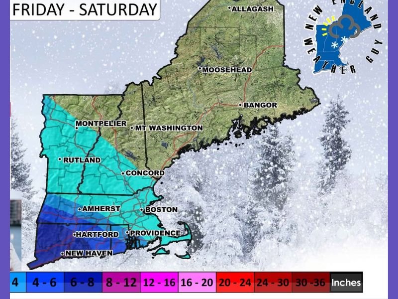
Accumulation Forecast Suggests Several Inches For Most Towns
Based on current projections, the majority of southern New England will see enough snow to require plowing. While the system had previously been expected to track slightly farther south, recent model runs indicate a push northward, increasing totals in parts of New Hampshire, Vermont and Massachusetts.
Forecasters described this northward shift as a “minor blip” from the latest model sets. Additional overnight runs will determine whether this trend continues or reverts to earlier expectations. Snow accumulation maps show a broad area of light-to-moderate snowfall across the region, with higher totals in interior areas and lower amounts toward coastal communities.
Bitter Cold Follows The Storm As Wind Chills Drop Into Negative Range
Once the system exits early Saturday, attention turns to dangerously cold conditions that will follow. Forecasters warn that Friday morning will start off extremely cold, with temperatures below zero or in the single digits across much of the region.
Wind chills will push into the negative double digits, creating dangerous conditions for anyone spending extended time outdoors. Even with some sunshine expected Saturday, temperatures will only climb into the 20s, keeping roads icy and untreated surfaces hazardous.
Another Potential Winter Threat Expected Sunday Into Monday
Meteorologists say another system could bring icing concerns late Sunday into Monday. While confidence in that forecast is still developing, early indicators suggest the possibility of freezing rain or mixed precipitation, which may create additional travel difficulties.
A final advisory on the Friday–Saturday storm is expected to be issued Friday morning. Residents are urged to prepare for slippery roads, reduced visibility and very cold temperatures, and to check for updates as models clarify the track and intensity of both the upcoming snow and the potential icing event early next week. For weather alerts and continuing updates, visit SaludaStandard-Sentinel.com.