Southern California Faces Renewed Flood Risk as New Storm System Brings Rain and Mountain Snow
CALIFORNIA — After a brief break from recent wet weather, Southern California is bracing for another Pacific storm system expected to arrive Thursday, bringing renewed threats of flooding, heavy rain, and mountain snow across the region.
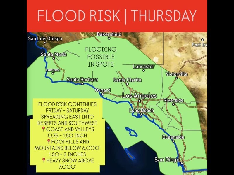
Meteorologists warn that flooding will be possible in spots from Santa Barbara to Los Angeles and San Diego, especially in coastal valleys, foothills, and mountain areas below 6,000 feet.
Rain Returns Thursday, Continues Into the Weekend
According to the latest forecast, widespread rain will redevelop Thursday afternoon and continue into Friday and Saturday, spreading east into the Inland Empire, deserts, and Southwest regions.
Expected rainfall totals include:
- 0.75 to 1.5 inches across coastal and valley areas.
- 1.5 to 3 inches in foothills and mountain zones below 6,000 feet.
- Heavy snow above 7,000 feet, creating hazardous travel conditions across higher passes.
This setup follows a week of back-to-back storms that have already saturated the ground, increasing the risk of runoff and flash flooding in low-lying regions.
Flooding Threats Across Los Angeles and Ventura Counties
Forecasters say areas around Los Angeles, Oxnard, and Santa Clarita could experience the heaviest rainfall, with minor urban flooding and debris flow potential in burn scar areas.
“Localized flooding and ponding on roadways are likely, especially where drains remain clogged,” the National Weather Service said in a Thursday advisory.
Drivers are urged to exercise caution on Highway 101, I-5, and I-15, where visibility may be reduced by heavy downpours and snow at higher elevations.
Snow Impacting Higher Elevations
In the mountains, snow levels will drop near 7,000 feet, where accumulations could exceed a foot in some areas. The San Gabriel and San Bernardino Mountains are expected to be hit hardest, potentially impacting travel through the Cajon Pass and other mountain corridors.
Officials have advised travelers heading toward the Sierra or local ski resorts to check conditions before leaving, as additional snow and icy conditions could persist through Saturday morning.
Flood Watch Likely to Extend Into Saturday
The flood risk will continue through Friday and into early Saturday as the storm pushes inland. By Saturday afternoon, forecasters expect rain to taper off from west to east, giving way to cooler, breezy conditions behind the front.
Meteorologists say more rain could return early next week as the active Pacific pattern continues to funnel moisture into California.
Residents are encouraged to avoid flooded roads, clear gutters, and stay alert for emergency alerts related to flash flooding or road closures.
Stay updated on this developing weather system and other U.S. regional forecasts by visiting SaludaStandard-Sentinel.com.