Southern California Faces Late-Night Squall Line With Heavy Rain, Lightning, Gusty Winds and Small Hail From Santa Barbara to Los Angeles
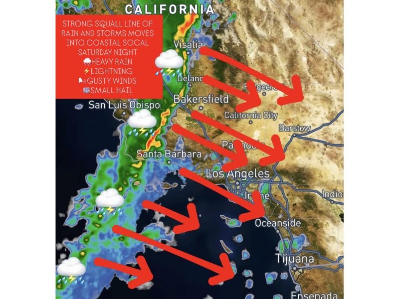
SOUTHERN CALIFORNIA — A fast-moving squall line is expected to push into the region late Saturday night, bringing a burst of intense weather conditions including heavy rain, lightning, strong winds, and even small hail across coastal and inland areas.
The system is tied to a strong cold front and is forecast to move quickly through key areas such as Santa Barbara, Los Angeles, and surrounding regions between approximately 11 PM Saturday and 2 AM Sunday, creating a short but impactful window of severe weather.
Strong Cold Front Driving Sudden Storm Development
The incoming squall line is associated with a sharp cold front that will rapidly intensify weather conditions as it reaches Southern California. This type of system is known for producing quick-hitting storms that can escalate in intensity within a short period of time.
Forecasters indicate that the line of showers and storms will form offshore before advancing inland, hitting coastal areas first and then pushing eastward toward inland valleys and desert regions. Cities including Santa Barbara, San Luis Obispo, and Los Angeles are directly in the path of this system.
Heavy Rain and Lightning Could Impact Nighttime Travel
One of the primary concerns with this squall line is the potential for very heavy downpours over a brief period. Rainfall could become intense enough to reduce visibility significantly, especially for drivers traveling late at night.
Lightning activity is also expected to accompany the storms, increasing the risk for sudden power disruptions and hazardous outdoor conditions. Residents with nighttime plans are being urged to stay alert as conditions may deteriorate quickly once the storms arrive.
Gusty Winds and Small Hail Possible in Strongest Cells
Along with heavy rain, the strongest storm cells embedded within the squall line could produce gusty winds capable of causing minor damage or blowing debris across roadways. These winds may arrive suddenly as the storm line passes through.
Additionally, there is a chance for small, pea-sized hail in isolated areas. While not expected to be widespread or damaging, hail could still create brief hazards, especially for drivers and outdoor surfaces.
Timing and Areas Most at Risk
The most active period is expected between late Saturday night and early Sunday morning, roughly from 11 PM to 2 AM. Coastal regions will likely experience impacts first, followed by inland communities as the system tracks east.
Areas from San Luis Obispo down through Santa Barbara and into Los Angeles are expected to see the most direct impacts, with storm activity gradually weakening as it moves further inland.
Residents Urged to Plan Ahead
Because the storms are expected overnight, many residents may be caught off guard. Officials recommend planning ahead, especially for those with late-night travel or outdoor activities.
Drivers should be prepared for sudden weather changes, including slick roads, reduced visibility, and possible debris. Staying informed and monitoring local updates will be critical during the storm window.
This fast-moving system is not expected to linger, but its intensity during the short timeframe could still create disruptions across Southern California.
If you’re in the affected areas, share your experience or weather updates with us at SaludaStandard-Sentinel.com and let others know what conditions look like in your community.