Southern California Braces for Week-Long “Raiden Storm Pattern” as Series of Strong Systems Threaten Heavy Rain, Mountain Snow, and Possible Pass Closures
LOS ANGELES, CALIFORNIA — A powerful series of storms is expected to move into Southern California during the week of February 16, 2026, as a weather setup known as a “Raiden Storm Pattern” takes hold, bringing the threat of heavy rainfall, significant mountain snow, and potential travel disruptions across key mountain passes.
Forecasters indicate the most active period will begin early in the week and continue through Wednesday, with additional systems likely extending unsettled conditions through the remainder of the week.
Heavy Rainfall Expected Across Coastal and Valley Areas
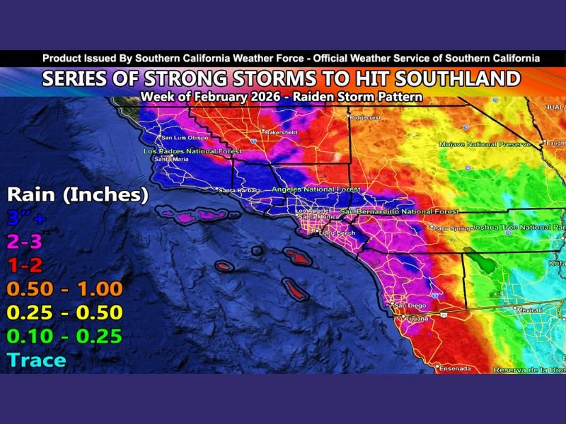
Rainfall projections show widespread totals exceeding seasonal averages across much of Southern California. Coastal and valley communities from Los Angeles to San Diego are forecast to receive substantial precipitation, with some areas potentially seeing more than 2 to 3 inches of rain.
Mountain-facing regions and foothills could receive even higher totals, particularly along the Transverse and Peninsular Ranges. Forecasters also note that thunderstorm potential will be evaluated as the event draws closer, raising the possibility of locally heavier downpours.
The bulk of the rainfall is expected to begin on February 16 and continue through midweek before tapering slightly, though additional rain chances remain in the extended outlook.
Snow Levels Drop to 4,000 Feet, Impacting Major Passes
Snow levels are projected to drop to around 4,000 feet, which would bring accumulating snow to both the Gorman Pass and Cajon Pass. Travel through these key corridors could be significantly affected, with the potential for closures or California Highway Patrol escorts if snowfall becomes heavy.
Resort-level snow totals are expected to exceed the 2- to 3-foot mark in higher elevations, signaling a substantial winter storm impact for Southern California’s mountain communities.
While many High Desert locations may remain above the primary snow line, localized areas such as Phelan could see snowfall due to rain-shadow effects and colder low-level air filtering in.
Regional Differences Across the Southland
Forecast maps indicate a sharp gradient in precipitation totals. Coastal counties and mountain regions appear positioned for the highest rainfall, while desert communities east of the mountains may see lighter amounts.
Los Padres National Forest, Angeles National Forest, and San Bernardino National Forest areas are among those expected to receive significant precipitation, with higher elevations accumulating heavy snow. Officials caution that rainfall intensity, snow totals, and thunderstorm potential will be refined as updated forecast models become available in the coming days.
Extended Storm Activity Through the Week
While the most concentrated precipitation appears likely between Monday and Wednesday of that week, additional rain and snow events are expected to remain within the broader forecast window through the rest of the week. This pattern could push seasonal rainfall totals above average and significantly improve snowpack levels in Southern California’s mountain ranges.
Residents are encouraged to monitor official forecasts for updates on timing, rainfall intensity, and potential travel impacts, especially across major mountain passes. How is your area preparing for the incoming storms? Share your local conditions and thoughts with us at SaludaStandard-Sentinel.com.