Southeast States See Growing Snow Potential as Long-Range Models Signal Colder Pattern and Active Storm Track
SOUTHEASTERN UNITED STATES — Snow chances remain low for now, but forecasters say signals are gradually increasing across parts of the Southeast as colder air begins to push farther south and storm systems continue to track through the region. Meteorologists emphasize that this is not a specific storm forecast, but rather an evolving pattern that could favor snow opportunities in the coming weeks if current trends continue.
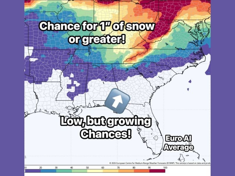
European Model Averages Show Growing Snow Signals
The outlook is based on an average of 51 European (ECMWF) model runs, which forecasters consider a more reliable method than focusing on a single model solution. This ensemble approach helps smooth out extremes and provides a clearer picture of long-term trends. Current data shows slowly expanding probabilities for at least one inch of snow, extending farther south compared to recent outlooks. While probabilities remain modest, the trend itself is noteworthy for early January.
Colder Air and Active Storm Track Create Favorable Setup
Forecasters say the key factor driving increased snow potential is the combination of building cold air and a persistently active storm track. Colder air masses are beginning to penetrate deeper into the Southeast, while storm systems continue to move across the region instead of staying north.
This overlap matters. Without cold air, storms bring rain. Without storms, cold air stays dry. When both occur together, even briefly, snow becomes possible in areas that typically see winter precipitation only rarely.
Where Snow Chances Are Slowly Increasing
Model data suggests growing snow probabilities across parts of the Lower Mississippi Valley, Tennessee Valley, and portions of the interior Southeast, with signals edging farther south over time. However, forecasters caution that coastal areas and far southern zones still show very low odds at this stage. Small shifts in temperature profiles or storm paths could dramatically change outcomes, making precise location forecasts impossible this far out.
No Specific Storms Yet, Pattern Is the Focus
Meteorologists stress that no individual storm or date has been identified. Instead, this outlook focuses on the broader atmospheric pattern expected to unfold over the coming weeks. As long as cold air continues to press southward and storm systems remain frequent, snow potential will stay on the table — even if exact timing remains uncertain.
What Residents Should Know Going Forward
While this is not a call to prepare for immediate winter weather, residents across the Southeast are encouraged to stay informed as the pattern evolves. Snow lovers may want to keep a close eye on forecasts, while others should be aware that winter weather surprises become more likely when conditions align.
Forecasters say updates will continue as confidence improves and shorter-range models begin to resolve individual systems. Are you hoping for snow this winter, or glad it’s staying uncertain for now? Share your thoughts and follow ongoing weather coverage at SaludaStandard-Sentinel.com.