South Mississippi and Alabama Brace for Heavy Rain as Gulf Coast Faces 2–4 Inches of Downpour Through Friday Night
MOBILE, AL — The Gulf Coast is preparing for a soaking end to the week as a moisture-rich system pushes heavy rain and thunderstorms across South Mississippi and Alabama from Thursday through late Friday night. New data from the GFS forecast model shows rainfall totals ranging between 2 to 4 inches, with localized areas possibly seeing even higher amounts near the coast.
Meteorologists warn that persistent, slow-moving bands of rain could lead to localized flooding, especially in low-lying areas and neighborhoods with poor drainage. The heaviest rain is expected between Thursday evening and midnight Friday, with conditions improving slowly over the weekend.
Forecast Calls for Days of Steady Rain Along the Gulf Coast
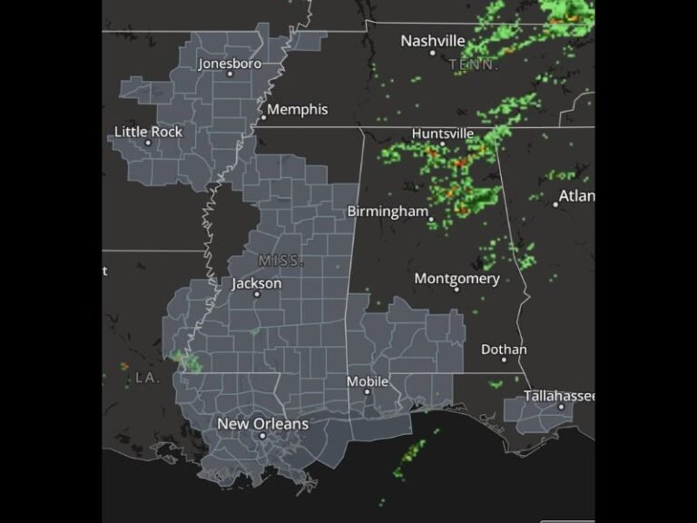
According to WeatherBell Analytics, the latest GFS precipitation model highlights a distinct red-and-orange band extending across southern Mississippi, southern Alabama, and the western Florida Panhandle. This area is projected to receive the heaviest rainfall, with totals exceeding 3 inches in some Gulf-front communities such as Pascagoula, Gulfport, and Mobile.
Further east, Pensacola could also see 2 to 3 inches of rain as the system drifts along the coastline, while interior regions such as Hattiesburg and Evergreen are forecast to pick up between 1 and 2 inches.
Forecasters say the Gulf moisture surge is being fueled by warm air colliding with cooler temperatures inland — a combination that enhances instability and sustains heavy rainfall rates.
Local Officials Caution Against Flooding Hazards
The National Weather Service offices in Mobile and Jackson are monitoring the potential for minor flash flooding across urban areas, small streams, and creeks. Residents are urged to secure outdoor items, including trash cans and decorations, as strong gusts and saturated soil could lead to scattered debris.
Emergency officials in Grand Bay, Pascagoula, Mobile, and Gulfport have issued precautionary alerts encouraging drivers to avoid water-covered roads and reminding residents that just a few inches of moving water can sweep away vehicles.
“Even though this isn’t a tropical system, it’s packing tropical moisture,” one local forecaster said. “People need to treat this seriously, especially overnight when visibility drops.”
Timing the Worst of the Weather
The heaviest rain is expected to arrive late Thursday afternoon, continuing through Friday morning, with some thunderstorms embedded within the rainbands. While widespread severe weather is not expected, gusty winds and isolated lightning could accompany heavier downpours.
By Friday night, the rain is expected to taper off from west to east, but forecasters caution that wet ground conditions will linger, keeping flood risks elevated into the early weekend.
Residents Advised to Stay Weather-Aware
Authorities recommend the following safety measures as the Gulf Coast braces for the storm:
- Avoid travel during periods of heavy rain and flash flood warnings.
- Move vehicles to higher ground if flooding is likely in your area.
- Check drainage systems around your home to ensure water can flow freely.
- Stay tuned to local weather alerts and updates throughout Thursday and Friday.
As of now, no widespread flood warnings have been issued, but forecasters say the situation could evolve quickly if rainfall intensifies.
By Friday night, most of Mississippi, Alabama, and the western Florida Panhandle will have seen a significant soaking — marking one of the region’s wettest early December weekends so far this season.
For continued weather updates and regional coverage, visit SaludaStandard-Sentinel.com.