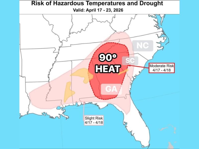
South Carolina, North Carolina, and Georgia Face Rare April Heat Wave With 90 Degree Temperatures and Growing Flash Drought Risk Next Week
SOUTH CAROLINA, NORTH CAROLINA, GEORGIA — A significant and unusual warm-up is expected to grip large parts of the Southeast next week, with temperatures soaring toward 90 degrees and raising concerns about both hazardous heat and developing drought conditions.
The pattern, which is rare for April, is being closely monitored as it could bring a combination of intense warmth and rapidly drying conditions across the region.
Temperatures Surge Toward 90 Degrees Across the Southeast
Forecast data shows a widespread area of above-normal temperatures building across South Carolina, North Carolina, and Georgia. Some locations are expected to approach or exceed 90 degrees, levels more typical of early summer than mid-April.
This sudden spike represents a major shift from seasonal norms and signals a strong warming trend that could impact daily routines and outdoor activity. The heat is expected to peak during the period from April 17 through April 23.
Moderate Risk of Hazardous Heat Identified
Parts of the region, especially across central areas of Georgia and the Carolinas, have been highlighted under a moderate risk zone for hazardous heat conditions between April 17 and April 18.
This designation indicates an increased potential for heat-related impacts, particularly for vulnerable populations such as older adults, children, and those without adequate cooling. Officials are urging residents to begin preparing for early-season heat by staying hydrated and limiting exposure during peak afternoon hours.
Flash Drought Conditions Could Develop Quickly
In addition to the heat, areas highlighted in yellow on forecast maps indicate a growing concern for flash drought development. These conditions can form rapidly when high temperatures combine with dry weather patterns.
The intense warmth accelerates evaporation and dries out soil quickly, increasing stress on vegetation and water resources. If the pattern persists, parts of the Southeast could see noticeable impacts in a short period of time.
Unusual April Pattern Signals Early Start to Summer-Like Conditions
This type of heat event is uncommon for April and suggests a highly amplified weather pattern. The combination of sustained warmth and limited rainfall is a key factor driving both the heat risk and drought concerns.
Residents across the region may feel as though summer has arrived weeks earlier than expected. Such early-season heat waves can also strain energy systems as cooling demand rises.
Residents Urged to Prepare for Rapid Weather Shift
With temperatures climbing quickly and dry conditions developing, officials recommend taking early precautions. This includes monitoring local forecasts, conserving water where possible, and checking on vulnerable individuals. Pet owners are also advised to ensure animals have access to shade and water as conditions warm rapidly.
The coming days will be critical in determining how intense and long-lasting this pattern becomes. If you’re noticing early signs of heat or dry conditions in your area, share your experience with us at SaludaStandard-Sentinel.com.