South Carolina Faces Repeated January Cold Blasts, but Forecast Models Agree Snow Chances Remain Very Low Statewide
SOUTH CAROLINA — Hopes for measurable snow across South Carolina are steadily fading, as updated forecast data shows snow chances dropping even lower heading into the second half of January, despite multiple rounds of cold air moving through the region. Meteorologists now say the pattern remains too dry and poorly timed to support meaningful snowfall. Forecasters emphasize that while winter cold will be felt repeatedly, the necessary overlap between cold air and moisture continues to fall apart.
Why Snow Chances Are Declining
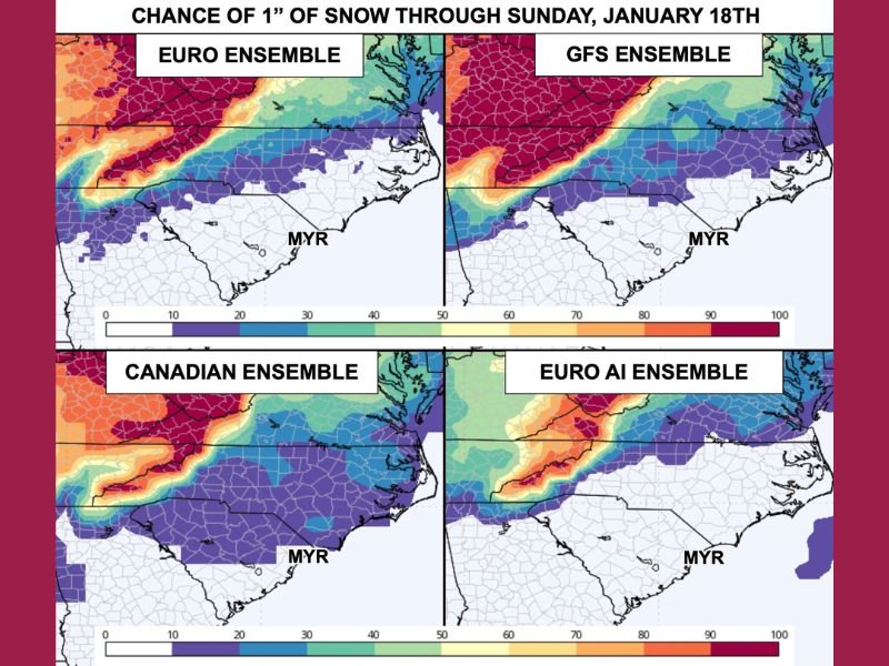
Over the past several days, global forecast models have trended noticeably drier, reducing what were already low snow probabilities. Updated ensemble guidance now suggests less than a 10% chance of seeing even 1 inch of snow across much of the state. This shift reflects a classic winter problem for the Southeast: cold air arriving too late, after available moisture has already moved offshore.
Two Systems to Watch — But Neither Favors Snow
Forecasters are monitoring two separate weather systems, one expected Thursday and another next Sunday. At this time, both systems are projected to track north of South Carolina, a setup that historically works against snow development in the region.
In these scenarios:
- Rain exits first
- Cold air follows behind
- Precipitation ends before temperatures drop enough for snow
This pattern, often described as “cold air chasing moisture,” rarely produces measurable snowfall in South Carolina.
What the Models Are Saying
More than 150 forecast simulations from four major global weather models were analyzed. The overwhelming consensus keeps snow probabilities below 10%, even as colder air repeatedly moves in. While the Canadian Ensemble continues to hint at occasional wintry outcomes, meteorologists caution that this model frequently overestimates snow potential in marginal Southeast setups.
Cold Air Is Still Coming — Multiple Rounds Ahead
While snow chances remain slim, cold air is a certainty. South Carolina is expected to experience several cold fronts, including:
- Another surge today
- Additional cold air Monday
- A stronger push Thursday
- Yet another cold shot next weekend
Each front reinforces the colder pattern, but none currently align with sufficient moisture to produce snow.
Why Snow Is So Hard to Get in South Carolina
Snow in South Carolina requires perfect timing — cold air, moisture, and storm track must align almost exactly. Even small shifts in any one of those factors can eliminate snow entirely. Forecasters stress that most winter cold patterns do not automatically translate into snowfall, especially in the Southeast, where moisture availability is often fleeting.
Bottom Line for the Week Ahead
At this point, measurable snow across South Carolina appears unlikely, despite repeated cold air intrusions. While winter jackets will stay in use, snow lovers may need to keep waiting.
Meteorologists will continue watching trends closely, but residents are advised to focus on cold weather preparedness rather than snow impacts for now. Stay with SaludaStandard-Sentinel.com for continued updates as each cold front approaches and forecast confidence increases.