South Carolina Braces for Potentially Biggest Snowstorm Since 1989 as 6–12 Inches Target Inland Areas This Weekend
SOUTH CAROLINA — A powerful winter storm moving up the Southeast coast could deliver South Carolina’s most significant snowfall in decades, with forecasters warning that some inland areas may see up to a foot of snow between Saturday afternoon and early Sunday morning.
Meteorologists say this system has the potential to rival historic snow events, with heavy snow developing rapidly Saturday night before tapering off early Sunday.
Snow and Rain Transition Expected Saturday
Forecast data shows snow and rain showers developing Saturday morning, gradually transitioning to all snow by Saturday afternoon as colder air deepens across the region. Snowfall is expected to intensify Saturday night, when the storm’s core passes closest to the coast.
By early Sunday morning, precipitation should begin to exit, but not before leaving behind widespread accumulations across much of the state.
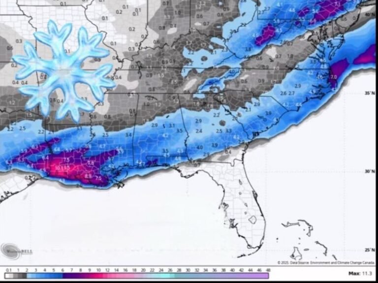
Inland Snow Totals Could Reach 6–12 Inches
According to the latest projections, most inland portions of South Carolina are expected to receive 6 to 8 inches of snow on average, with localized totals potentially reaching 12 inches in areas that experience prolonged heavy snow bands.
Communities across central and northeastern South Carolina appear particularly vulnerable to higher totals, where colder air is expected to hold firm throughout the event.
Coastal Areas May See Lower Totals Due to Rain
Along the coast, especially south of Myrtle Beach, warmer air near the shoreline could cause more rain to mix in, limiting snow accumulations. Forecasts currently suggest coastal totals closer to 3 to 6 inches, with snowfall amounts decreasing closer to the immediate shoreline.
Even so, officials warn that rapid temperature drops Saturday night could still create hazardous travel conditions.
A Rare Setup with Historic Potential
Forecasters describe the storm as unusual in strength and structure for the Carolinas, noting that the combination of moisture, cold air, and storm track is rarely aligned this well. That alignment is why some experts are calling it South Carolina’s most impactful snowstorm since 1989.
Residents are urged to prepare for difficult travel, possible power disruptions, and rapidly changing conditions, especially overnight Saturday.
Saluda Standard-Sentinel will continue tracking this storm closely and provide updates as new forecasts are released. For ongoing coverage and local weather alerts, visit SaludaStandard-Sentinel.com.