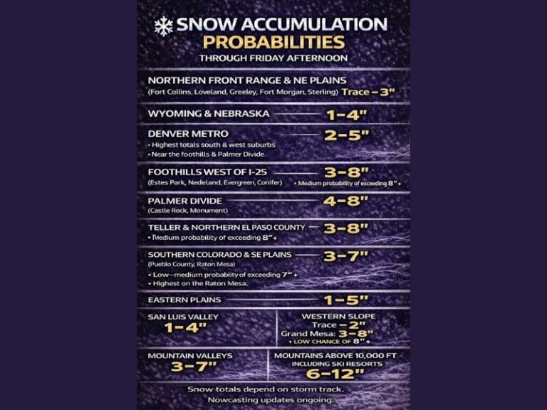
South Carolina and North Carolina Face 60–70% Risk of Major Winter Storm Impacts as NOAA Warns of Near-Impossible Travel Conditions
SOUTH CAROLINA & NORTH CAROLINA — New federal guidance shows a high likelihood of major winter storm impacts across large portions of the Carolinas, with NOAA placing areas along and east of Greenville, South Carolina, into a 60–70% risk zone for conditions severe enough to significantly disrupt daily life.
According to the latest national winter storm outlook, the threat level signals dangerous travel, widespread closures, and potentially prolonged disruptions, particularly as heavy snow bands intensify across the region.
What NOAA Means by “Major” Winter Storm Impacts
NOAA defines a “major” winter storm impact as one that brings significant disruption to daily life, including near-impossible driving conditions and the potential for widespread business, school, and government closures.
Meteorologists note that the current snowfall projections strongly support this classification, especially across central and eastern sections of both states where snowfall rates could overwhelm road treatment efforts.
Areas at Highest Risk Across the Carolinas
The highest probability zone stretches from upstate South Carolina through central North Carolina, encompassing cities such as Greenville, Columbia, Charlotte, Raleigh, and Greensboro.
Within this corridor, snowfall intensity is expected to vary sharply due to banded precipitation, meaning some communities may experience extreme conditions, while nearby locations see noticeably lower totals.
Why Travel Conditions Could Become Nearly Impossible
Forecasters warn that snowfall rates may exceed one to two inches per hour at times, especially beneath persistent snow bands. When combined with falling temperatures and increasing winds, roads could quickly become impassable.
Emergency managers are preparing for scenarios that include:
- Multi-hour travel shutdowns
- Stranded motorists
- Delayed emergency response times
- Extended hazardous conditions even after snowfall tapers
Closures and Disruptions Likely
With the level of impact projected, officials caution that school closures, government shutdowns, and business interruptions are increasingly likely across affected counties.
Power disruptions cannot be ruled out, especially in areas where snow accumulation combines with gusty winds and already stressed infrastructure.
Bottom Line for Residents
Confidence is growing that this storm will significantly affect daily life across both South Carolina and North Carolina. While exact snowfall totals will vary by location, the risk of major impacts is high enough that residents should finalize preparations now.
Travel should be avoided once conditions deteriorate, and households are urged to plan for extended periods indoors if snow bands linger.
Stay with SaludaStandard-Sentinel.com for continued updates, localized impact breakdowns, and official advisories as this major winter storm unfolds.