South Carolina and North Carolina Could See Light Accumulating Snow This Weekend After Historic Ice Event
SOUTH CAROLINA AND NORTH CAROLINA — Another winter system is beginning to take shape across the Carolinas, with light accumulating snow possible from Friday night into Saturday, just days after parts of the region experienced some of the highest ice totals seen in more than two decades. While this upcoming system is not expected to be aggressive, forecasters say it is showing enough consistency to warrant close monitoring.
Forecast Models Show Consistent Snow Signal
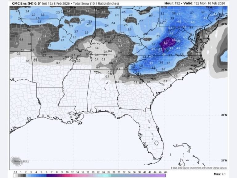
Both major forecast models continue to show snow developing across portions of South Carolina and North Carolina, particularly from the Upstate of South Carolina into western and central North Carolina. The latest guidance suggests snow would begin late Friday night and continue into Saturday, with light but measurable accumulations possible.
At this stage, heavy snowfall is not indicated, but the consistency across multiple model runs suggests this is not just a one-off solution.
Recent Ice Damage Adds Extra Concern
This potential snow comes on the heels of an extraordinary ice event, especially across northern Greenville County, where ice totals may have reached levels not seen in at least 21 years. Some areas could be looking at record-setting ice accumulation, stressing trees and power infrastructure.
Forecasters believe previous storm damage may actually reduce outage impacts, as weakened limbs and brush were already cleared during earlier storms. Still, any new winter precipitation adds risk, especially if snow weighs down already-damaged trees.
Weekend Impacts Expected to Be Manageable
If current trends hold, travel impacts should remain limited, with snow amounts expected to stay light. However, overnight and early morning travel could be affected, particularly on untreated roads, bridges, and elevated surfaces.
Temperatures will remain cold enough for snow to stick in some areas, but widespread disruptions are not expected at this time.
Weather Fatigue Becoming a Factor
Forecasters are also acknowledging weather fatigue across the region, as communities continue to recover from repeated winter events. Many residents are still dealing with cleanup, power restoration, and lingering stress from the recent ice storm.
Officials stress the importance of staying informed without panic, noting that awareness — not alarm — is the goal heading into the weekend.
What to Expect Going Forward
Forecast updates will continue through the week, with snow chances refined as the system draws closer. Residents are encouraged to remain prepared but understand that this system appears far less impactful than recent storms.
What are conditions like where you live? Share your thoughts and stay weather-aware with continued updates from SaludaStandard-Sentinel.com.


