Severe Weather Threat to Drench Mississippi, Alabama, Louisiana, and Georgia with Heavy Rain and Storms This Weekend
JACKSON, MISSISSIPPI — A major multi-day storm system is expected to bring heavy rain, strong winds, and isolated severe weather to the Deep South beginning Saturday evening and continuing through Tuesday night, with forecasters warning of localized flooding and possible tornadoes in several states.
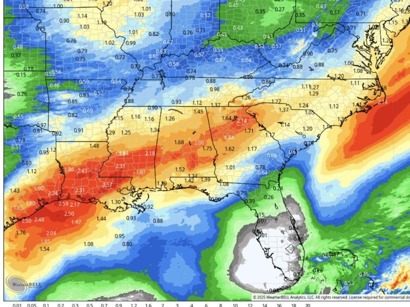
The latest rainfall projections from WeatherBell Analytics show an expansive corridor of 2 to 3 inches of rain stretching from southern Louisiana and Mississippi through central Alabama and Georgia, making this one of the wettest systems to hit the region so far this fall.
Heavy Rain and Severe Storms to Begin Saturday
The event is expected to kick off Saturday night as moisture from the Gulf of Mexico surges northward into an approaching frontal boundary. This setup will generate repeated rounds of thunderstorms, bringing periods of torrential rain, thunder, and gusty winds through early next week.
According to forecasters, rainfall totals may exceed:
- 2.5 to 2.9 inches in parts of southern Louisiana and Mississippi
- 2.0 to 2.3 inches across central Alabama
- 1.6 to 2.1 inches across western Georgia and the Carolinas’ upstate regions
“This isn’t just your typical weekend rain,” said one meteorologist analyzing the model data. “We’re talking about a system that’s capable of flooding roadways, knocking out power with strong winds, and producing isolated tornadoes in the Gulf states.”
Localized Flooding and Severe Weather Potential
The National Weather Service warns that the system could lead to flash flooding in low-lying and poorly drained areas, especially across southern Mississippi, southeastern Louisiana, and southwestern Alabama, where the heaviest rain bands are expected to stall for several hours.
In addition to flooding risks, atmospheric conditions could also support severe thunderstorms with gusty winds and small tornadoes, particularly on Saturday night and Sunday.
Areas under elevated severe weather risk include:
- Southern and central Mississippi
- Southeast Louisiana
- Southwest and central Alabama
- Western Georgia and the Florida Panhandle
These regions could see intense bursts of rain, lightning, and brief rotating storms capable of producing wind damage.
Impact on Residents
Residents are urged to remain weather-aware throughout the weekend, as conditions are expected to deteriorate quickly once storms arrive. Prolonged heavy rain could lead to urban flooding, road closures, and travel delays, especially along major highways such as I-10, I-20, and I-59.
Local emergency officials recommend:
- Charging phones and power banks before storms arrive.
- Avoiding parking beneath trees or power lines due to wind risks.
- Keeping storm kits with flashlights, batteries, and bottled water.
- Monitoring alerts from trusted weather services for potential tornado watches or warnings.
State-by-State Overview
- Mississippi: Heaviest rainfall expected in southern and central counties, possibly exceeding 2.5 inches. Flash flooding may occur in areas around Jackson and Hattiesburg.
- Alabama: Central Alabama could see up to 2.2 inches of rain with embedded thunderstorms; gusty winds may cause minor power outages.
- Louisiana: The system’s core moisture source lies here, with widespread rainfall of 2–3 inches and occasional severe thunderstorm activity through Sunday night.
- Georgia: North and central Georgia may see steady soaking rains of 1.5–2 inches, contributing to localized flooding in urban areas.
Meanwhile, Florida is expected to remain on the fringe of the system, seeing lighter rainfall but still dealing with gusty winds along the Panhandle.
Outlook Through Tuesday
The storm system will slowly push eastward by Monday, extending the heavy rain threat across Georgia and the Carolinas before tapering off late Tuesday night.
Behind the system, forecasters expect cooler and drier air to return midweek, marking the beginning of a more stable pattern into early December.
“Between the flash flood potential, gusty winds, and isolated tornadoes, this system has the ingredients for a messy few days,” meteorologists warned. “People across the Deep South should take it seriously, even if it starts as just rain.”
Stay connected to SaludaStandard-Sentinel.com for continuing updates, regional advisories, and safety alerts as this developing system impacts the Southeast through early next week.