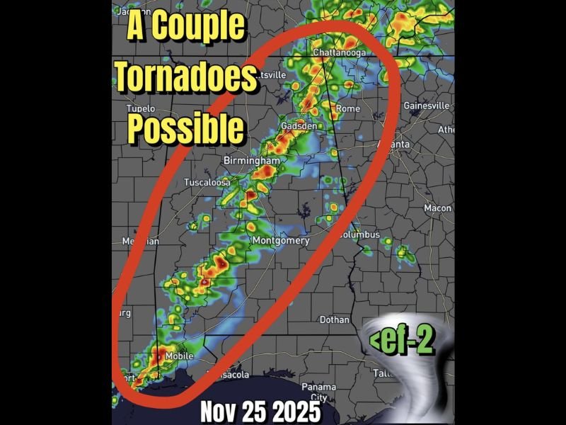
Severe Weather Threat Across Alabama as Cold Front Brings Risk of Tornadoes and Strong Storms
BIRMINGHAM, ALABAMA — Forecasters are warning residents across Alabama to prepare for another round of severe weather this afternoon and evening, as a cold front moving east is expected to spark supercell thunderstorms capable of producing a couple of tornadoes. The most at-risk areas include Mobile, Montgomery, Tuscaloosa, and Birmingham, where atmospheric conditions are favorable for rotating storms.
Cold Front Could Trigger Tornado Development
According to weather models, a line of strong thunderstorms will develop ahead of the cold front pushing through the state. Forecasters say these storms may organize into supercells, which can lead to brief tornadoes, damaging winds, and heavy rainfall through Tuesday evening.
The greatest risk appears to extend from southern Alabama near Mobile through central parts of the state, reaching up toward Gadsden and Chattanooga later tonight. Meteorologists warn that EF-1 to EF-2 strength tornadoes are possible, particularly where isolated cells form ahead of the main squall line.
Forecasters Urge Residents to Stay Alert
Meteorologists urge residents to monitor weather alerts throughout the evening and have multiple ways to receive warnings. “This setup has the potential for a few strong tornadoes, especially if any storms can stay isolated long enough to rotate,” forecasters noted.
Areas including Montgomery, Birmingham, and Tuscaloosa could also experience wind gusts exceeding 60 mph, hail, and localized flash flooding. The line of storms is expected to move eastward into western Georgia by late tonight.
Preparedness and Safety Measures
The National Weather Service advises residents to avoid travel during warnings, secure outdoor objects, and identify a safe shelter area such as an interior room on the lowest floor of a sturdy building. Tornado watches and warnings are likely to be issued as the system intensifies through the evening.
Authorities also recommend charging mobile devices and keeping weather radios nearby in case of power outages.
Forecasters emphasize that while widespread tornado activity is not guaranteed, conditions remain favorable for a few isolated but potentially strong twisters. The threat is expected to diminish overnight as the cold front pushes toward Georgia and the Florida Panhandle.
Stay weather-aware and follow local emergency management updates for the latest alerts.
For continuing severe weather coverage, visit SaludaStandard-Sentinel.com.