Severe Thunderstorms Could Target Jackson, Mississippi Region Saturday Evening Before Weakening Toward the Pine Belt
MISSISSIPPI — Showers and thunderstorms are expected to develop across parts of Mississippi Saturday evening, with the greatest risk for severe weather likely north and west of Jackson before storms gradually weaken as they approach the Pine Belt region.
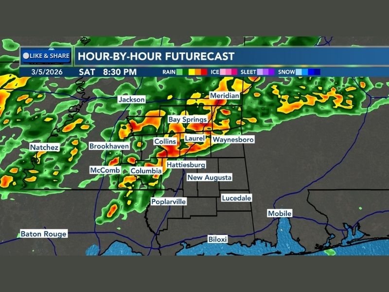
Forecast models show a line of storms moving eastward across the state during the evening hours, potentially bringing heavy rain, lightning, and strong thunderstorms to several communities. While severe weather is not expected everywhere, meteorologists warn that storms could intensify in areas surrounding Jackson before spreading farther south and east.
The system is expected to move across central Mississippi during the evening hours, creating a period of unsettled weather for residents traveling or spending time outdoors Saturday night.
Storm Line Expected to Develop West of Jackson
Weather models indicate that thunderstorms will begin forming west of Jackson before gradually moving east across central Mississippi. Communities such as Natchez, Brookhaven, and McComb may see storms develop first before activity spreads toward Jackson later in the evening.
As the storms move across the region, heavier downpours and stronger thunderstorm cells could form near the Jackson metropolitan area. Some storms may briefly reach severe levels as atmospheric conditions become favorable for stronger thunderstorm development. Meteorologists say storms in this area may produce strong winds, heavy rainfall, and frequent lightning, particularly during the early evening hours.
Strongest Storm Risk North and West of the Capital
Forecasters say the greatest potential for stronger storms appears to be north and west of Jackson, where conditions could allow thunderstorms to organize and intensify.
Communities in this zone could experience heavier rain bands and stronger storm cores as the system moves across the region. While widespread severe weather is not guaranteed, isolated stronger thunderstorms could still produce gusty winds and intense rainfall. Areas farther south and east may still experience storms, but the intensity is expected to gradually decrease as the system moves across Mississippi.
Pine Belt Region Expected to See Weaker Storms
As the storm system continues east and southeast, meteorologists expect the thunderstorms to weaken before reaching the Pine Belt region.
Cities such as Hattiesburg, Laurel, and nearby communities may still see rain and thunderstorms later in the evening, but the storms are expected to lose some of their strength compared to those forming earlier near Jackson.
Even weakening storms, however, can still produce heavy rain, lightning, and brief gusty winds. Residents in the Pine Belt should still remain alert for rapidly changing weather conditions Saturday evening.
Rainfall and Lightning Likely Across Much of Central Mississippi
While the severe threat may be limited to certain areas, widespread showers and thunderstorms could still affect much of central Mississippi.
Storm cells are expected to move through several communities including Bay Springs, Collins, Waynesboro, and Columbia during the evening hours. Localized downpours could reduce visibility on roads and create temporary travel hazards.
Lightning will also be a major concern with these storms, especially for anyone attending outdoor events or traveling during the evening hours. Meteorologists recommend keeping an eye on weather updates and being prepared to move indoors if thunderstorms approach.
If thunderstorms develop in your area Saturday evening, share your local weather conditions and storm photos with our newsroom at SaludaStandard-Sentinel.com as we continue covering developing weather across the United States.