Severe Thunderstorm Watch Issued for Southern California: Los Angeles, San Diego, and Inland Empire at Risk for Hail, Lightning, and Flooding
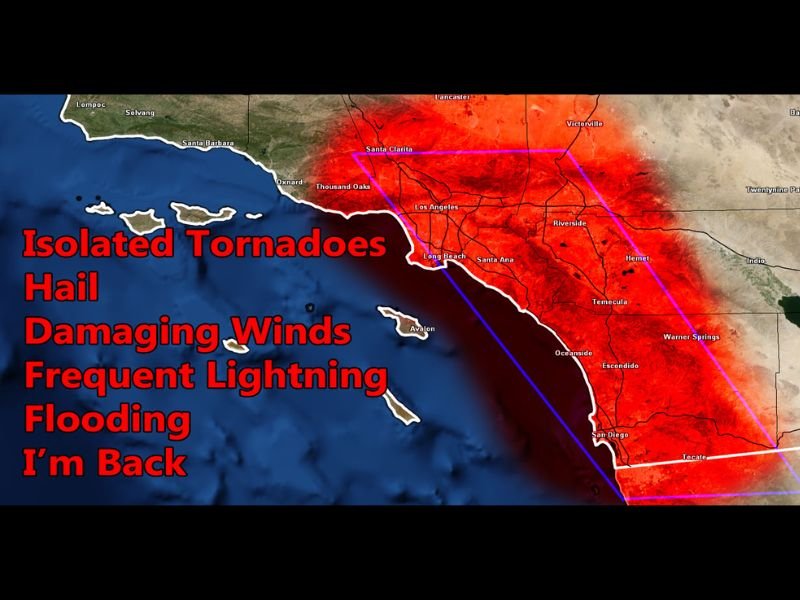
CALIFORNIA — A Severe Thunderstorm Watch has been issued for Southern California, with forecasters warning of potentially the largest thunderstorm-producing system of the season arriving Thursday evening and lasting through early Friday.
The Southern California Weather Force (SCWF) issued the alert for several counties, including Los Angeles, Orange, San Diego, Riverside, and San Bernardino, as well as the High Desert, Cajon Pass, and Inland Empire.
Powerful System to Bring Lightning, Hail, and Flooding
The system, which developed from strong upper-level divergence moving out of the Northwest, is expected to unleash frequent lightning, damaging winds, large hail, isolated tornadoes, and flash flooding across the affected zones.
According to meteorologist Raiden Storm of SCWF, this storm will closely resemble the Valentine’s Day system earlier this year, which produced widespread thunderstorm activity and flash flooding across Southern California.
“This looks like the largest thunderstorm-producing system we’ve seen this year,” Storm explained. “Expect intense lightning displays, localized flooding, and gusty winds as colder air moves in and instability builds.”
The most severe impacts are expected Thursday evening through early Friday morning, with conditions easing by sunrise Friday.
Areas Most at Risk
- Los Angeles County: Heavy rain, strong gusts, and lightning near the coast and valley regions
- Orange and San Diego Counties: Potential for hail and localized flooding, especially in low-lying areas
- Inland Empire and High Desert: Increased risk of damaging winds and isolated tornadoes
- Mountain Regions (San Bernardino & Riverside): Heavy rain transitioning to snow at higher elevations

Thunderstorm Watch Details
The Severe Thunderstorm Watch remains in effect from Thursday evening, November 20, through Friday morning, November 21.
- Wind gusts: Over 50 mph possible
- Hail: Up to 1 inch diameter in strongest cells
- Rainfall totals: Up to 1.5 inches in coastal and mountain areas
- Tornado potential: Low but present, particularly in the Inland Empire
The Southern California Weather Force stresses that this is an exclusive forecast, warning that “frequent lightning, isolated tornadoes, and damaging winds will all be in play.”
Residents Urged to Stay Alert
Officials are urging residents to avoid flooded roadways, secure outdoor objects, and stay indoors during lightning activity. Those in higher-risk areas should have a reliable method to receive warnings overnight, such as weather radios or mobile alerts.
Forecasters also emphasized that lead time and preparation are crucial:
“When 50% or more of a watch zone has potential for severe weather, it’s vital that the public takes warnings seriously,” SCWF said.
Stay Updated
You can track the storm’s movement and updates through the ZoneWatch Radar and Model Dashboard, which provides real-time forecasts and severe weather alerts.
Stay safe and stay informed with continuous updates at SaludaStandard-Sentinel.com.