Severe Rainstorm Soaks East Texas, Louisiana, and Mississippi as Cold Front Brings Sudden Temperature Drop Across the Gulf States
SHREVEPORT, LA — A widespread storm system sweeping across East Texas, Louisiana, and Mississippi is bringing relentless rainfall, thunderstorms, and rapidly dropping temperatures, signaling one of the season’s strongest cold fronts for the Gulf Coast region. Meteorologists warn that the front will expand eastward through Alabama and the Florida Panhandle, producing a sharp contrast between tropical moisture and winter-like cold.
Heavy Rain and Thunderstorms Dominate Early Week Forecast
Radar imagery shows a thick band of moderate to heavy rain extending from Houston through Shreveport and into Jackson, with embedded thunderstorms and gusty winds spreading east. The system is drenching large portions of Louisiana and Mississippi, creating travel delays and flooding risks in low-lying areas.
Residents in the affected states have reported nearly nonstop rainfall, with some describing the conditions as “torrential” and “unrelenting.” Forecasters confirm that several inches of rain may accumulate before the front pushes through later Tuesday night.
Meanwhile, Arkansas has been dealing with its own version of winter weather chaos. Some areas are seeing a mix of rain, sleet, and light snow, turning highways slick and visibility poor. Meteorologists say the state sits near the collision zone between warm Gulf air and the Arctic blast dropping down from the Plains.
Gulf Coast States Next in Line for the Storm
The storm’s next target includes Mississippi’s Gulf Coast, southern Alabama, and northwest Florida, where the rain is expected to arrive by late afternoon and persist into the evening. Weather experts say the front will move quickly, but its impact will be felt through a combination of strong winds, dropping temperatures, and lingering moisture overnight.
Communities from Mobile to Pensacola could experience thunderstorms followed by a sudden temperature dive as the front passes. The region’s warmth will be replaced by a noticeably cold air mass, marking a swift end to the humid conditions that have lingered for days.
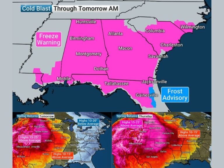
Sharp Temperature Drop Follows the Rain
Behind the rain comes what forecasters are calling a “disrespectfully cold” air mass, set to send temperatures plunging across the lower Mississippi Valley. The front’s arrival could cause a 15–20 degree temperature drop in just a few hours, bringing overnight lows into the upper 30s and 40s for parts of Mississippi and Louisiana.
Residents have reported strong wind gusts that make the chill feel even more severe, and forecasters say this could be the start of a multi-day cool pattern across the Southeast. The cold air’s intensity is expected to make heaters work overtime through midweek.
Residents Warned to Prepare for Fast-Changing Conditions
The National Weather Service is urging people across the Gulf region to prepare for rapid temperature changes, heavy rainfall, and potential wind gusts as the front continues moving east. Drivers are advised to use caution on rain-slick roads and stay alert for possible ponding or flash flooding in rural areas.
As one weather commentator joked, “This setup has more mood swings than a toddler at Walmart,” highlighting the dramatic shift between humid storms and biting cold that the region will experience within 24 hours.
If you’re in Texas, Louisiana, Mississippi, or Alabama, how is the sudden shift in weather affecting your week? Share your experience and photos with us at SaludaStandard-Sentinel.com.