Severe Friday Storm Threat Expands From Wisconsin to Texas With Potential EF2+ Tornadoes, 75+ MPH Winds and Large Hail
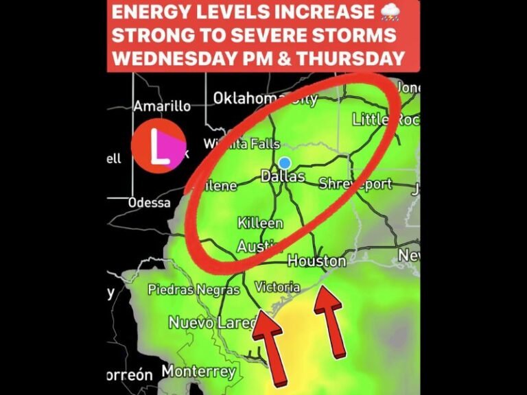
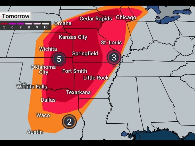
UNITED STATES — Meteorologists are warning that Friday could bring a dangerous outbreak of severe storms stretching from Wisconsin to Texas, with the greatest tornado threat expected from Madison, Wisconsin, southward through Missouri, Arkansas, Oklahoma, and into the Dallas, Texas region.
Forecasters say storms may develop earlier in the day, but the most dangerous conditions are expected Friday evening and overnight, when supercells could intensify and produce tornadoes, destructive winds, and large hail.
Tornado Risk Could Include Strong EF2+ Storms
Weather experts say tornado development is possible along a large corridor of the central United States, particularly across areas including:
- Wisconsin
- Illinois
- Missouri
- Arkansas
- Oklahoma
- Texas
Some tornadoes could become stronger EF2 or greater, especially where storms form into rotating supercells.
Cities near the center of the threat zone include Chicago, Cedar Rapids, St. Louis, Kansas City, Springfield, Oklahoma City, and Dallas, all within or near the severe weather corridor.
Large Portion of Central U.S. Faces Severe Weather
Forecast maps show a broad area under heightened storm risk stretching from the Upper Midwest through the Plains and into North Texas.
Meteorologists say multiple rounds of storms could develop, with the most significant activity occurring during the evening hours as atmospheric conditions become more unstable. Communities across the region are being urged to closely monitor weather alerts as conditions evolve throughout the day.
Damaging Winds Could Exceed 75 MPH
While tornadoes are a major concern, experts say extreme winds may affect an even larger number of people. Forecast guidance indicates storms could produce wind gusts exceeding 75 mph, capable of bringing down trees and power lines.
Residents are being warned that such winds could cause scattered power outages and property damage, particularly in areas where storms organize into fast-moving squall lines.
Large Hail Threat Also Expected
Another significant hazard associated with the system is large hail, with some storms capable of producing hail two inches in diameter or larger.
Hail of this size can cause damage to vehicles, roofs, and crops, and can also pose a risk to people caught outdoors. Meteorologists advise residents to park vehicles in garages or covered areas if possible before storms begin developing.
Officials Urge Residents to Prepare Ahead of Storms
With storms expected to intensify later in the day, experts recommend that residents across the threat zone review safety plans and stay alert for rapidly changing weather conditions.
Having multiple ways to receive weather alerts — especially overnight — can be critical if warnings are issued. People are encouraged to secure outdoor items, prepare for potential power outages, and identify safe shelter locations in case tornado warnings are issued.
As the storm system develops, meteorologists will continue monitoring the atmosphere for signs of supercells capable of producing dangerous tornadoes and severe weather across the central United States. Have severe storms affected your area recently? Share your weather experiences or photos with readers at SaludaStandard-Sentinel.com.