Rare February Tornado Threat Targets the Ohio Valley Thursday as Supercells Could Form From Illinois to Kentucky and Ohio
OHIO VALLEY — A rare February tornado threat is being monitored for Thursday, with forecasters warning that a few tornadoes could develop as unusually warm, humid air surges north and strong winds increase across the region.
Why This Setup Is Unusual for February
February can produce severe weather, but conditions supportive of tornado-producing supercells are not common this time of year. In this case, temperatures are expected to run unseasonably warm, with dew points climbing toward the upper 50s to low 60s, an important ingredient that helps storms stay strong and rotating.
Forecasters say this moisture, combined with a strong storm system and powerful low-level winds, could set the stage for storms capable of producing tornadoes.
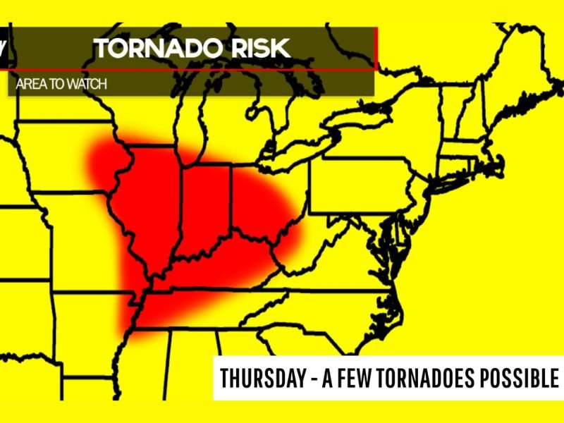
Where Tornadoes Could Develop and How Storms May Move
The “area to watch” highlighted for Thursday includes a large portion of the Ohio Valley. The greatest concern is for storms that begin in Illinois and along the Mississippi River during the afternoon, then move east toward Indiana, Kentucky, and Ohio.
If storms remain more isolated and can rotate freely, the tornado risk increases. If storms quickly merge into a larger line, the main threat can shift more toward damaging straight-line winds—though brief spin-ups can still happen along a line.
SPC Day 4 Outlook Shows a 15% Slight Risk
The Storm Prediction Center’s Day 4 outlook has included a 15% Slight Risk, which is being described as notable for this point in the season and a sign that forecasters see enough ingredients lining up to warrant early attention. That does not guarantee tornadoes will occur, but it is a clear signal that Thursday’s setup is one to track closely as confidence and details sharpen.
What Residents Should Do Before Thursday Arrives
If you live anywhere in the Ohio Valley risk area, make sure you have multiple ways to receive warnings—especially if storms arrive during work hours or after dark. Charge phones, review your safe place (lowest level, interior room), and avoid relying on outdoor sirens as your only alert method.
Have you noticed the warm, humid air building where you are? Share what you’re seeing—and how your community prepares for severe weather—at SaludaStandard-Sentinel.com.