Rapidly Intensifying Bombogenesis Cyclone to Bring Blizzard Conditions, Severe Storms, Flash Freeze and 40–70 MPH Winds Across the Midwest and Great Lakes
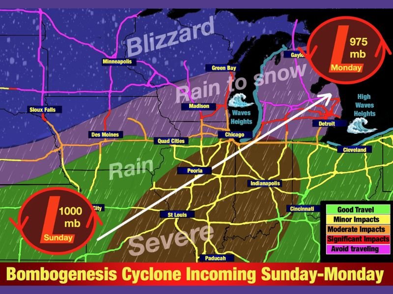
MIDWEST & GREAT LAKES REGION — Meteorologists warn that a rapidly intensifying bombogenesis cyclone will sweep across the Midwest and Great Lakes from Sunday into Monday, bringing widespread 40–70 mph winds, blizzard conditions, severe thunderstorms, and a potentially dangerous flash freeze as temperatures plunge sharply behind the system.
Cyclone Expected to Deepen by 24 Millibars in 24 Hours
Forecasters confirm that the incoming storm meets the criteria for bombogenesis, a process in which a storm system intensifies extremely quickly by dropping 24 millibars or more within one day. Latest guidance suggests this rapid intensification is highly likely, signaling a powerful and disruptive winter event.
With the system strengthening aggressively, the pressure is expected to fall from around 1000 mb Sunday to near 975 mb by Monday, placing the region under a high-impact wind and snow threat.
Blizzard Conditions Likely in Upper Midwest
The northern and northwestern sides of the storm will see heavy snow combined with strong winds, creating blizzard-like conditions across parts of the Upper Midwest. Snowfall totals may reach a foot in some locations, with 2–3 feet possible in the Upper Peninsula of Michigan. Forecasters warn that blowing snow will significantly reduce visibility and make travel dangerous or impossible at times.
Severe Storms Expected South of the System
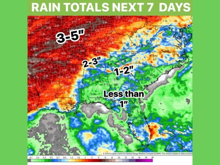
South of the low-pressure center, the warm sector of the storm will spark severe thunderstorms, which could produce hail, damaging winds, and even isolated tornadoes across portions of Illinois, Indiana, and Missouri. This region may also experience heavy rainfall and localized flooding.
Temperatures Could Crash 20–30 Degrees in One Hour
Meteorologists say areas in the storm’s warm sector could see temperatures drop 20–30 degrees in just one hour as the cold front surges through. This abrupt shift will likely lead to a flash freeze, creating icy conditions across roads, bridges, and sidewalks in multiple states. Forecasters are urging drivers to plan ahead, as conditions may deteriorate rapidly with little warning.
High Winds and Major Waves Expected on the Great Lakes
With winds along the lakes expected to reach 60–70 mph, forecasters warn that wave heights may exceed 20 feet, posing dangers to vessels and reducing visibility along coastal areas. The strong wind field may also result in scattered power outages, tree damage, and hazardous travel through Monday.
Pressure Drop Could Also Cause Physical Symptoms in Sensitive Individuals
The significant atmospheric pressure change may impact residents sensitive to such fluctuations. Meteorologists note that joint pain and headaches could worsen as the storm deepens.
This storm represents one of the most dynamic winter systems of the season, combining multiple hazards—snow, wind, severe weather, temperature collapse, and icy roads—within a short time frame. Residents across the Midwest and Great Lakes are encouraged to follow local forecasts closely and share storm updates with SaludaStandard-Sentinel.com as the system unfolds.