Presidents Day Weekend Storm to Soak Texas, Oklahoma and Arkansas With 2–3 Inches of Rain, Severe Threat Emerging Friday Night
DALLAS, TEXAS — A developing late-week storm system is poised to bring much-needed rainfall to drought-stricken parts of Texas, Oklahoma, and Arkansas as the region heads into the Presidents Day holiday weekend. Forecast guidance shows widespread rain totals between 1.5 and 3 inches, with locally higher amounts possible, particularly from north Texas through southern Oklahoma and into central Arkansas.
In addition to beneficial rainfall, forecasters are closely monitoring Friday night into Saturday for the potential of severe thunderstorms, including damaging winds and isolated tornadoes.
Rainfall Axis Targets Drought Areas
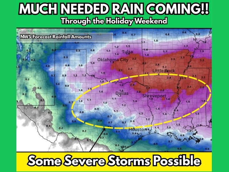
National Weather Service rainfall projections indicate the heaviest precipitation corridor extending from Dallas and north Texas northeastward toward Oklahoma City, Tulsa, Little Rock, and Shreveport. Many locations within this zone are forecast to receive 2 to 3 inches of rain, with some localized totals potentially exceeding that range.
Cities including Oklahoma City, Tulsa, Dallas, Little Rock, and Shreveport appear near the center of the higher rainfall band. This moisture is expected to provide meaningful relief in areas where drought conditions have gradually worsened through winter.
Southern portions of Texas, including Houston and coastal areas, may see lighter totals closer to 0.5 to 1 inch, while central and northern sections receive heavier coverage.
Severe Storm Risk Increasing Late Friday
Meteorologists are keeping a close eye on Friday night into early Saturday, as a compact but dynamic upper-level trough moves through the region. Model guidance suggests increasing moisture and instability, which could support widespread thunderstorms.
While the exact placement and intensity remain uncertain, forecasters note the possibility of damaging winds and isolated tornadoes, particularly in areas from north Texas into Arkansas and western Mississippi. The system’s timing and evolving instability parameters will determine how organized storms become.
At this time, the severe threat appears conditional but notable enough to warrant continued monitoring.
Holiday Weekend Travel Considerations
With rain spreading across much of Texas, Oklahoma, and Arkansas heading into the holiday weekend, travel impacts are likely. Wet roads, reduced visibility, and potential thunderstorms could affect drivers traveling between major cities such as Dallas, Oklahoma City, Little Rock, and Shreveport.
If severe storms develop, localized power outages or brief disruptions could occur. Residents are encouraged to stay updated on forecast changes as higher-resolution data becomes available.
Drought Relief With Caution
The broader theme of this system is beneficial rainfall. Many communities across Texas, Oklahoma, and Arkansas have seen drought conditions steadily intensify through winter. This incoming moisture may significantly improve short-term soil conditions and reservoir levels.
However, heavier rainfall in short timeframes could also lead to localized flooding in urban and low-lying areas. Balancing drought relief with storm preparedness will be key for residents throughout the region.
As Presidents Day weekend approaches with an active weather pattern across the southern Plains, staying informed remains critical. For continued national weather coverage and updates that could impact travel, concerts, and live events across the country, visit saludastandard-sentinel.com.