Powerful Pacific Storm System Forecast to Bring Extreme Rainfall, Flooding, and Heavy Mountain Snow Across Washington and Oregon Throughout the Week
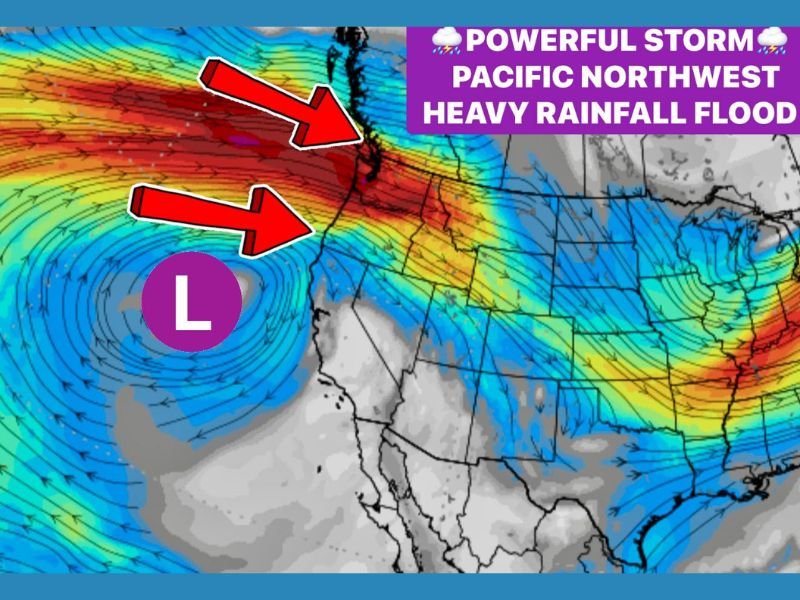
WASHINGTON & OREGON — A powerful and prolonged storm pattern is setting up across the Pacific Northwest, with multiple systems expected to batter Washington and Oregon throughout the week. Meteorologists warn of extreme rainfall, flooding potential, landslide risks, strong winds, and heavy mountain snow as deep Pacific moisture repeatedly surges into the region.
Atmospheric River and Jet Stream Combine to Create Week-Long Storm Parade
Forecast data shows that the Pacific Northwest will be impacted by multiple storm systems lined up across the ocean, fueled by a strong jet stream and several atmospheric river pulses. These systems aim directly toward the Washington and Oregon coastlines, ensuring frequent waves of significant weather impacts.
Moisture-rich air masses will repeatedly crash into the mountains and coastline, creating conditions for high-impact rainfall and widespread disruption.
Rainfall Totals May Reach 8–12 Inches With Isolated Areas Approaching a Foot
Forecasters expect extreme rainfall amounts, particularly along:
- The Washington and Oregon coastlines
- Coast Range foothills
- Cascade Range slopes
By the end of the week, some areas may pick up 8–12 inches of rain, with isolated locations potentially reaching a full foot, enough to trigger:
- Flash flooding
- Landslides
- Swollen rivers and stream overflow
Hydrologists warn that saturated soils will only heighten the risk as storms continue day after day.
Cascades to Receive 1–3 Feet of Snow as Snow Levels Fluctuate
Snowfall will also be significant. The Cascades in Washington and Oregon are forecast to receive:
- 1–3 feet of new snow, depending on elevation
- Periods of rapidly changing snow levels due to alternating surges of warm and cold air
Travelers can expect dangerous driving conditions, including chain requirements, whiteouts, and increased avalanche risk in higher terrain.
Coastal Winds to Remain Gusty With Travel Impacts Through the Week
Strong winds will accompany the storm sequence, especially along exposed coastal areas. Frequent gusts will lead to:
- Difficult driving for high-profile vehicles
- Tree limb breakage and isolated outages
- Marine hazards across coastal waters
Meanwhile, inland travel through the Cascades will become increasingly challenging as snow accumulates and visibility decreases.
More Storms Expected as Pattern Remains Active
Meteorologists note that this storm pattern is part of a broader atmospheric setup that could remain active beyond the weekend. Additional storm energy may continue to funnel toward the Pacific Northwest even after the heaviest rainfall passes.
Officials encourage residents in flood-prone or landslide-susceptible areas to prepare in advance and monitor emergency alerts closely.
How will this week-long storm system impact your plans in Washington or Oregon? Share your thoughts with us at SaludaStandard-Sentinel.com.