Pennsylvania Sees Early March Warmth With Temperatures Near 80°F Before Severe Storms and Cold Front Return
PENNSYLVANIA — Much of the state experienced an unusually warm early March day Tuesday as temperatures surged well above seasonal averages, with some areas reaching the upper 70s and even low 80s before a major weather shift arrives later this week.
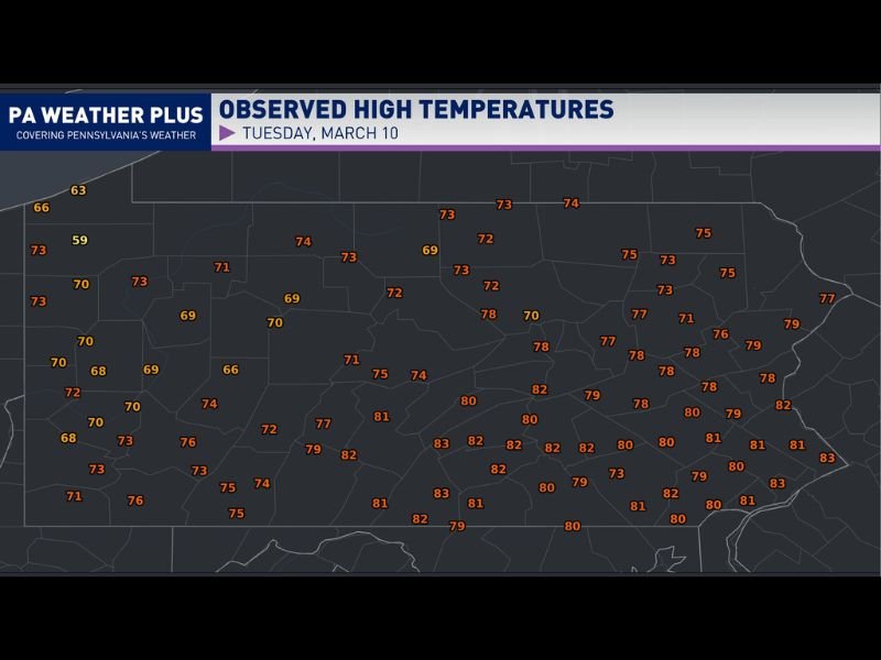
Western Pennsylvania generally saw afternoon highs climb into the upper 60s and low 70s, while eastern portions of the state warmed even more dramatically. Several locations in eastern Pennsylvania reached the upper 70s to low 80s, making it feel more like late spring than early March.
Meteorologists say the brief warm spell comes ahead of an approaching storm system expected to bring severe thunderstorms Wednesday followed by significantly colder air on Thursday.
Eastern Pennsylvania Climbs Into the 80s
Weather observations across the state showed a noticeable temperature contrast from west to east. Cities and towns across western Pennsylvania mostly recorded highs ranging from the upper 60s to the lower 70s during the afternoon. Meanwhile, eastern and southeastern parts of the state experienced the warmest conditions of the day.
Many locations reported temperatures between 78°F and 83°F. Several areas across the southeastern portion of Pennsylvania reached around 82°F to 83°F during the peak of the afternoon warmth. These readings are significantly warmer than the average early March temperatures typically seen across the state.
Dry and Sunny Conditions Dominated Tuesday
The warm temperatures were supported by dry and sunny weather across much of Pennsylvania throughout the day. Clear skies and sunshine allowed temperatures to rise quickly during the afternoon hours. With minimal cloud cover and little precipitation, many residents across the state enjoyed one of the warmest days so far this year.
Meteorologists noted that the pleasant conditions were the result of a warm air mass pushing northward across the Mid-Atlantic region. However, the quiet weather is not expected to last long as a stronger weather system begins approaching the region.
Severe Thunderstorms Expected Wednesday
Forecasters say thunderstorms are expected to return to the region on Wednesday as a strong cold front moves toward Pennsylvania. The incoming system could trigger severe thunderstorms capable of producing strong winds, heavy rain, and lightning across parts of the state.
While the exact timing and severity of storms may vary depending on location, the developing weather pattern suggests that Wednesday could bring a much more active weather day compared to the calm and sunny conditions experienced Tuesday. Meteorologists are continuing to monitor the system as it moves closer to the region.
Cold Air Arrives Behind the Storm System
Once the storms pass, a dramatic change in temperatures is expected. A sweeping cold front moving through the region will push significantly colder air into Pennsylvania by Thursday. This shift will likely bring temperatures back closer to seasonal levels and mark the end of the brief early spring warmth.
Weather patterns like this are common during early March, when warm air surges northward ahead of strong storm systems before colder air quickly returns behind them. Residents across Pennsylvania are encouraged to enjoy the warm weather while it lasts and remain aware of changing weather conditions as thunderstorms move into the forecast.
Readers who experienced the unusually warm temperatures or upcoming storms in their communities can share their experiences and follow continued weather updates at SaludaStandard-Sentinel.com.