Pennsylvania Hit by Back Door Cold Front as Temperatures Crash From 70s to 30s Across Eastern Areas With Sharp Divide Statewide
PENNSYLVANIA — A dramatic temperature shift is unfolding across the state as a rare “back door” cold front pushes inland, sending eastern Pennsylvania plunging into much colder conditions while western areas remain unseasonably warm.
The unusual setup has created a striking contrast, with some parts of the state experiencing spring-like warmth while others feel more like late winter within just a few hours.
Sharp Temperature Divide Sets Up Across the State
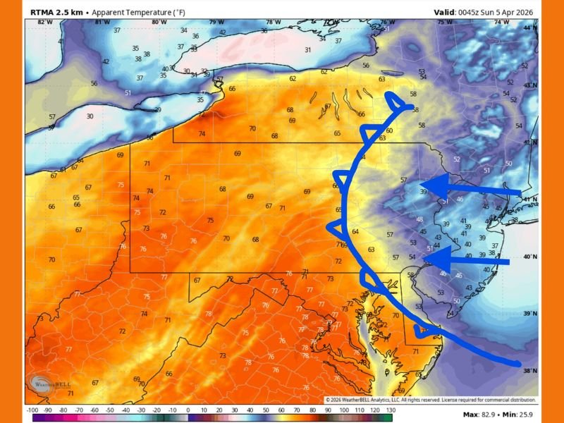
Weather data shows western and central Pennsylvania holding onto mild temperatures in the upper 60s to mid-70s. Meanwhile, eastern Pennsylvania—including areas closer to New Jersey and the Atlantic influence—has seen temperatures drop sharply.
In these eastern regions, “feels like” temperatures have fallen into the 40s and even upper 30s in some locations, creating a noticeable and abrupt change in conditions.
Back Door Cold Front Moves Against Typical Pattern
Unlike most cold fronts that move west to east, this system is approaching from the opposite direction—moving inland from the Atlantic coast. This type of setup is known as a “back door” cold front.
The front is being driven by strong easterly winds and cooler ocean air, which is pushing inland and undercutting the warmer air mass already in place across Pennsylvania.
Rapid Cooling Felt Within Hours
The transition between warm and cold conditions has been swift, with some areas experiencing a drop from the 70s and even low 80s earlier in the day down into the 40s by evening.
This rapid shift highlights how quickly conditions can change when a back door front moves through, especially during the spring when temperature contrasts are more pronounced.
Coastal Influence Drives Colder Air Inland
The cooler air associated with this front is linked to colder Atlantic waters, which help reinforce the chilly air mass moving inland. As the front advances, more areas across eastern Pennsylvania are expected to feel the cooling effect.
The strength of the easterly winds has allowed the cold air to push farther inland than usual, expanding the reach of the colder conditions.
Unusual Spring Pattern Brings Weather Whiplash
This type of temperature swing is not uncommon during spring, but the intensity of the contrast—ranging from summer-like warmth to near-winter chill—has made this event particularly noticeable.
Residents across Pennsylvania are experiencing what many describe as “weather whiplash,” with conditions changing dramatically depending on location.
Residents Advised to Prepare for Sudden Changes
With such a sharp divide in temperatures, residents are encouraged to dress in layers and stay aware of changing conditions, especially when traveling between regions.
The cooler air is expected to remain in place across eastern parts of the state for a period before temperatures begin to stabilize.
If you’re noticing the sharp temperature drop in your area, share your experience with us at SaludaStandard-Sentinel.com and help others understand how conditions are changing across Pennsylvania.