Pennsylvania and the Northeast Face Late-Week Coastal Storm Risk as Models Disagree on Snowfall Extent for January 15–16
PENNSYLVANIA — A potential coastal winter storm late this week is drawing increased attention across Pennsylvania and the broader Northeast, as forecast models show widely different outcomes for Thursday into Friday, January 15–16. While some guidance suggests the risk for a larger snow event, other models indicate minimal impacts, highlighting a high-uncertainty forecast window that remains several days away.
Why This Late-Week Storm Is Being Watched Closely
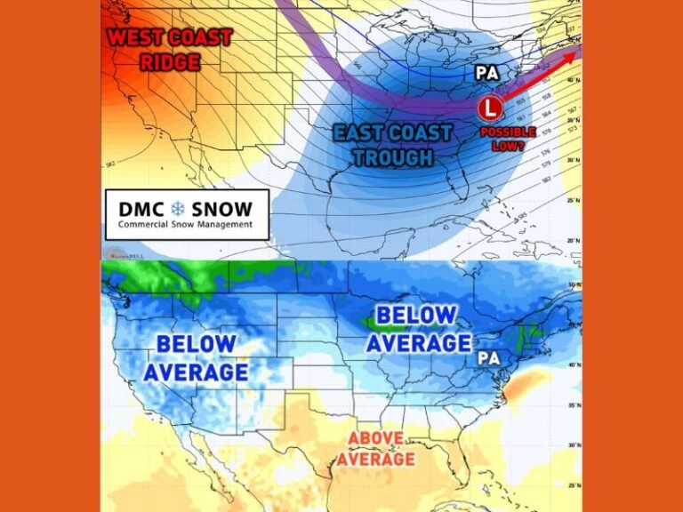
Forecasters say the ceiling for this system is higher than recent winter storms, largely due to a deeper upper-level trough expected to move into the eastern United States. If that trough digs far enough south, it could tap into subtropical jet energy and Gulf moisture, creating a moisture-loaded coastal storm capable of producing longer-duration snowfall.
However, meteorologists stress that high potential does not mean high confidence, especially at this range.
Major Model Disagreement Drives Uncertainty
One of the biggest challenges with this forecast is sharp disagreement among the main weather models.
The GFS model currently favors a more southern track, which would bring steadier and potentially heavier snow into parts of Pennsylvania and the central Northeast.
The ECMWF (European model) supports a middle-ground solution, suggesting moderate impacts with snow and rain depending on location. Meanwhile, the CMC (Canadian model) leans toward a northern solution, limiting impacts mainly to lake-effect snow and leaving much of Pennsylvania with little or no accumulation. This spread underscores why forecasters caution against focusing on any single snowfall map.
Timing Still Several Days Away
Even if this storm does materialize, impacts would not begin until Thursday morning at the earliest. With several days remaining, small changes in energy alignment, storm speed, or jet stream interaction could dramatically shift the outcome.
Forecasters note that misaligned upper-level energy or interference from another wave could reduce this system to minor snow showers or squalls, rather than a widespread storm.
High Ceiling, Low Floor Scenario
Meteorologists describe this setup as having a high ceiling but a very low basement. In other words, the storm has the ingredients to become significant, but it also has many ways to fail or weaken.
If the trough deepens and slows as some guidance suggests, Pennsylvania and parts of the Northeast could see a longer-lasting snow event. If not, impacts may be limited or negligible, especially inland.
What Residents Should and Should Not Do Right Now
Forecasters urge residents to stay informed without getting overhyped. Snow lovers are advised not to rely on early GFS snowfall outputs alone, while those who prefer advance notice should monitor updates over the coming days as confidence improves or fades.
At this stage, context matters more than totals, and official forecasts closer to midweek will provide clearer guidance. Have you been tracking this potential storm? Share your thoughts and stay updated with ongoing coverage from SaludaStandard-Sentinel.com, where we break down complex weather setups affecting communities across the United States.