Overnight Wednesday Storms to Bring Lightning, Small Hail, and Up to 3 Inches of Rain Across North Texas
TEXAS — Forecasters are warning residents across North and Central Texas to prepare for a series of overnight storms beginning late Wednesday night into Thursday, bringing frequent lightning, gusty winds, and small hail after nearly three weeks without significant rainfall.
Marginal Risk Issued for Severe Weather
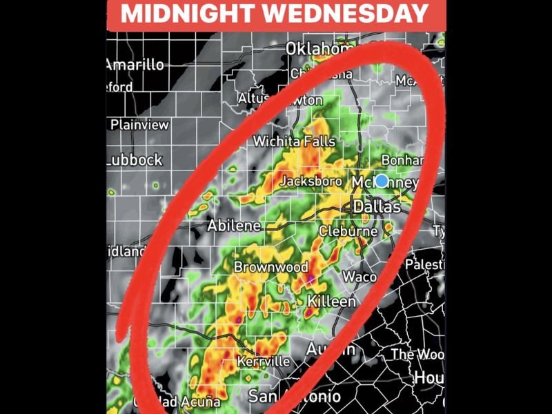
According to the National Weather Service, the region is under a Marginal Risk (Level 1 of 5) for isolated severe storms. The strongest cells are expected to move through Dallas, Fort Worth, Waco, and surrounding areas between midnight and early Thursday morning.
Weather radar models show a large cluster of thunderstorms forming near Abilene and Kerrville, stretching eastward overnight. While widespread severe weather is not expected, localized heavy rain and minor flooding could occur where storms repeatedly pass over the same areas.
Storm Timeline and Rainfall Expectations
Meteorologists expect the first round of storms to arrive just before midnight Wednesday and continue through daybreak. A second round is forecast Thursday morning, followed by a stronger line of storms Thursday afternoon into Thursday night.
Total rainfall amounts of 1 to 3 inches are likely across much of North and Central Texas, with isolated higher amounts possible in heavier downpours. The rain should taper off by Friday, bringing a brief break in the active pattern before more showers return Sunday into Monday.
End of a Three-Week Dry Stretch
The incoming storm system marks the first measurable rain in nearly three weeks, offering welcome relief for parched soil and low water levels. However, forecasters note that the rainfall may arrive too quickly for dry ground to absorb efficiently, which could cause minor street flooding or runoff issues in urban areas.
Residents Urged to Stay Weather-Aware
Officials are urging residents to monitor local forecasts and remain alert overnight. Lightning will be a primary hazard, along with strong wind gusts and small hail capable of damaging plants and vehicles left outdoors.
People are advised to secure outdoor items, avoid flooded roads, and stay indoors during thunderstorm activity.
Weather experts say that while this system is not expected to be widespread or long-lasting, it signals a shift toward more active winter weather patterns for North Texas in the coming weeks.
Have you seen lightning or heavy rain in your area tonight? Share your photos and weather reports with us at SaludaStandard-Sentinel.com.