Oklahoma, Texas and Kansas Under Tornado Watch Until Midnight as Supercells Begin Developing and Severe Storm Threat Intensifies
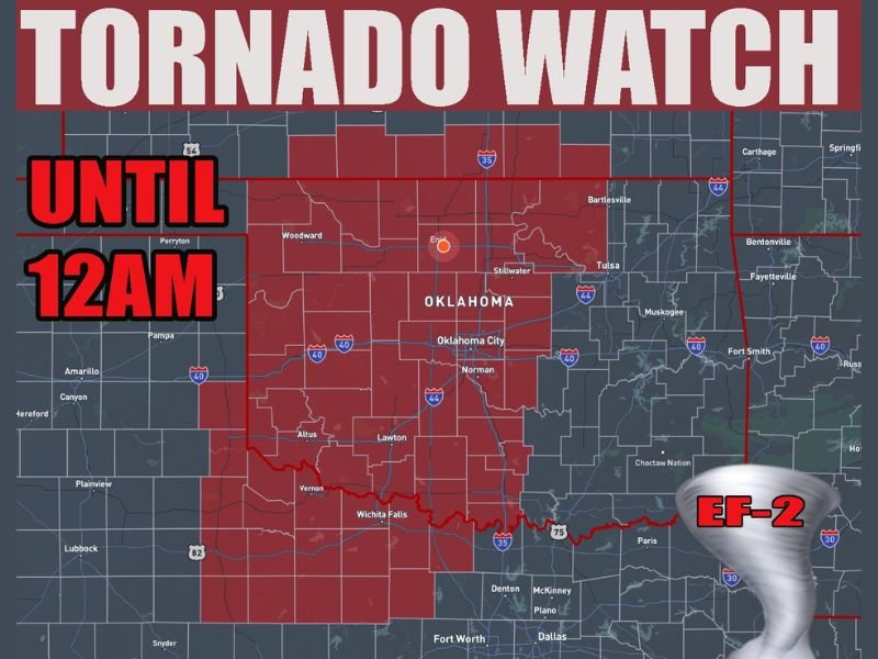
OKLAHOMA — A tornado watch has been issued across much of western Oklahoma, along with adjacent areas of Texas and Kansas, as severe storms begin to develop and conditions become increasingly favorable for dangerous weather.
The watch remains in effect until 12:00 AM, with forecasters warning that storms are already starting to form and could rapidly intensify through the evening hours.
Supercells Beginning to Form Across the Region
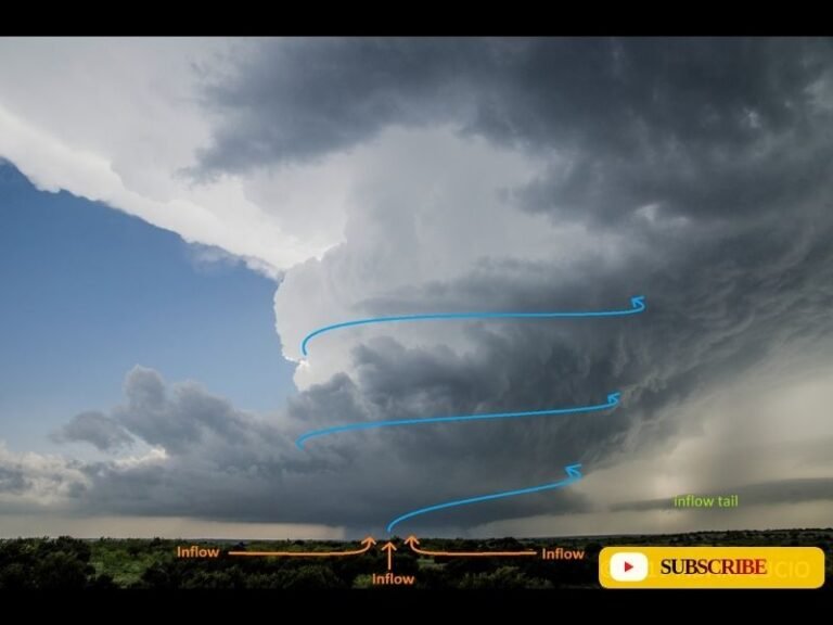
Weather data indicates that storms are currently initiating across western Oklahoma, with early development expected to evolve into organized supercells. These types of storms are known for producing the most severe weather, including tornadoes, large hail, and destructive winds.
As the evening progresses, these individual storms are expected to strengthen before eventually merging into a larger squall line that could sweep across the region overnight.
Meteorologists emphasize that the early phase of storm development—before the squall line forms—is when the highest tornado risk typically exists.
Wide Impact Area Across Oklahoma, Texas and Kansas
The tornado watch area covers a broad region, including:
- Much of western and central Oklahoma, including areas near Oklahoma City and Enid
- Northern Texas, particularly near Wichita Falls and areas along the Red River
- South-central Kansas, where storm development could extend northward
This multi-state setup highlights a classic severe weather pattern across the southern Plains, where warm, unstable air combines with strong wind dynamics to create a volatile environment.
Primary Threats Include Tornadoes and Large Hail
The main hazards associated with this system include:
- Tornado potential, with some storms capable of producing strong tornadoes
- Large hail, possibly exceeding 2 inches in diameter
- Damaging wind gusts as storms intensify and organize
The environment shown in the data strongly supports rotating storms, meaning even isolated cells could quickly become dangerous.
Storms Expected to Intensify Into the Night
Forecasters warn that storm activity will likely increase in both coverage and intensity through the evening hours. While initial storms may be scattered, a more widespread severe threat is expected as the system evolves.
The transition from discrete supercells to a squall line could bring an additional round of damaging winds later tonight, expanding the impact zone further east.
Residents should remain alert well into the overnight hours, as severe weather can continue after dark when visibility is low and warnings are harder to recognize.
Residents Urged to Prepare and Stay Alert
Officials are urging residents across Oklahoma, Texas, and Kansas to take precautions now, including:
- Reviewing tornado safety plans
- Ensuring access to weather alerts and warnings
- Identifying safe shelter locations in advance
This is a developing situation, and conditions may change quickly as storms mature. Residents in the affected areas are encouraged to share updates and stay informed with ongoing coverage at SaludaStandard-Sentinel.com as this severe weather event unfolds.