Oklahoma City Faces Incoming QLCS Bowing Storm Line With 70 MPH Winds, Golf Ball Hail and Embedded Tornado Risk Late Evening
OKLAHOMA CITY, OKLAHOMA — A powerful and fast-moving line of severe storms is advancing toward the Oklahoma City metro area this evening, bringing a significant threat of damaging winds, large hail, and possible embedded tornadoes.
The system, identified as a QLCS (Quasi-Linear Convective System) bowing segment, is pushing east from western Oklahoma and is expected to impact central parts of the state within a short timeframe.
Bowing Storm Line Intensifying Across Western Oklahoma
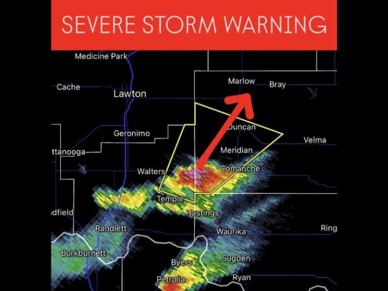
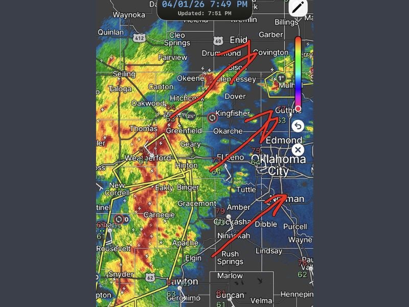
Radar imagery shows a well-defined bowing segment stretching from areas near Weatherford and Thomas down toward Carnegie and Lawton, indicating strong forward momentum and intensifying winds.
Communities including Greenfield, Hinton, and El Reno are already experiencing the leading edge of the storm, with the most intense activity marked by deep red and yellow radar returns—signs of heavy rain, strong winds, and embedded severe cells.
This type of storm structure is particularly dangerous because it can produce widespread wind damage while also hiding smaller, fast-forming tornadoes within the line.
Oklahoma City Metro Directly in Path
The storm is moving directly toward Oklahoma City, with surrounding areas such as Edmond, Yukon, Mustang, and Norman expected to be impacted shortly.
Arrows on radar projections indicate an eastward push, placing the metro area squarely in the storm’s trajectory. Residents in these locations should prepare for rapidly deteriorating conditions as the line approaches. Given the storm’s speed and intensity, impacts could begin with little warning.
Primary Threats Include Damaging Winds and Embedded Tornadoes
The biggest concern with this system is damaging straight-line winds up to 70 mph, which can cause downed trees, power outages, and structural damage.
Additionally, the storm is capable of producing:
- Golf ball-sized hail, particularly in stronger embedded cells
- Brief, fast-moving tornadoes that may form quickly within the line
- Frequent lightning and heavy rainfall, reducing visibility and creating hazardous travel conditions
QLCS systems are known for producing tornadoes that develop with minimal lead time, making it critical for residents to stay alert.
Storm Timing Critical for Evening Commute and Night Hours
The timing of this system raises additional concerns, as it is expected to impact the Oklahoma City area during the evening hours when many people may still be on the road or transitioning indoors.
Forecasters warn that visibility will decrease quickly as the storm arrives, and conditions could become dangerous in a matter of minutes. Residents are urged to complete travel and outdoor activities as soon as possible and prepare to shelter.
Residents Urged to Take Immediate Precautions
Emergency officials are advising those in the path of the storm to:
- Move to a sturdy structure and avoid windows
- Identify a safe interior room or basement
- Stay tuned to local weather alerts and warnings
- Avoid driving during the height of the storm
This is a fast-developing situation, and conditions may continue to worsen as the storm line strengthens.
Residents across Oklahoma City and surrounding areas are encouraged to stay informed and share updates as this severe weather event unfolds at SaludaStandard-Sentinel.com.