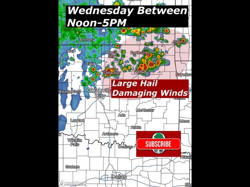
Oklahoma Cities Including Oklahoma City, Tulsa, Stillwater and Bartlesville Face Wednesday Storm Window With Large Hail and Damaging Winds Risk
OKLAHOMA — A round of scattered strong storms is expected to develop across central and northeastern Oklahoma on Wednesday, bringing the potential for large hail and damaging winds from midday into the afternoon hours.
Forecasters highlight a focused window between noon and 4 PM where storm activity could intensify quickly, especially in areas stretching from Oklahoma City through Tulsa and surrounding communities.
Primary Storm Window Targets Afternoon Hours
The most active period for storm development is expected between late morning and mid-afternoon, with scattered cells forming and strengthening across central and northeast Oklahoma.
Cities including Oklahoma City, Stillwater, Bartlesville, and Tulsa fall within the zone where storms could become more organized, producing brief but intense impacts.
Large Hail and Damaging Winds Main Concerns
The primary hazards with these storms will be large hail and strong wind gusts. Storm cores could produce hail capable of causing damage to vehicles and property, particularly in areas directly under the strongest updrafts.
Damaging winds are also a concern, with localized gusts strong enough to knock down tree limbs and create isolated power disruptions.
Storm Coverage Expected to Be Scattered but Impactful
Not every location will see storms, but the areas that do could experience rapid intensification within a short period. This type of setup often leads to highly variable conditions, where one community may see severe weather while another nearby remains dry. This makes it especially important for residents across the region to stay alert during the afternoon hours.
Second Round of Storms Possible Late Night
In addition to the afternoon activity, another line of storms is expected to move into the region later Wednesday night, after 10 PM. There remains some uncertainty regarding how strong this second round will be upon arrival. However, the potential exists for continued storm activity into the overnight hours, extending the overall risk window.
Residents Urged to Stay Weather Aware Throughout the Day
Officials advise residents to monitor weather updates closely, especially during the peak afternoon timeframe and again late at night. Having multiple ways to receive warnings is critical, particularly if storms redevelop after dark.
With two potential rounds of storms and varying intensity, staying prepared will be key across central and northeastern Oklahoma. Readers in Oklahoma can share storm reports or local conditions by visiting SaludaStandard-Sentinel.com.