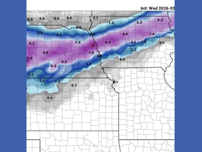
Oklahoma, Arkansas, and Missouri Face Expanded Thursday Tornado Risk as Isolated Storms Turn Dangerous After Dark
OKLAHOMA, ARKANSAS, MISSOURI — Forecasters are warning residents across parts of central and eastern Oklahoma, northwest Arkansas, southern Missouri, and portions of the Mid-South to stay alert Thursday as a low-end but concerning tornado risk expands westward, including areas east of Interstate 35. While the overall severe weather threat is expected to remain isolated, officials stress that even one rotating storm could produce a tornado, particularly after sunset when conditions become more favorable for storm organization.
Tornado Risk Area Expanded Westward Into Central and Eastern Oklahoma
Updated data shows the tornado risk has pushed farther west than earlier forecasts, now including parts of central Oklahoma, with the threat increasing as storms move east of I-35 into more unstable air.
Storms developing during the late morning and early afternoon hours may initially produce:
- Large hail
- Strong, gusty winds
- Brief rotation in stronger cells
Forecasters note that not every storm will be severe, but any storm that intensifies could become dangerous quickly.
After-Dark Storms Raise Concern for Nocturnal Tornadoes
The greatest concern comes after sunset, when strengthening upper-level winds are expected to increase deep-layer wind shear across the region. This setup may allow one or two storms to rotate strongly enough to produce tornadoes.
Key factors driving the nighttime threat include:
- Increasing wind shear after dark
- Multiple rounds of storm development
- Reduced visibility and warning response overnight
Meteorologists emphasize that nocturnal tornadoes are statistically the deadliest, largely because people are asleep when warnings are issued.
Timing and Areas Most at Risk on Thursday
The threat window varies by location but generally follows this timeline:
- Late morning to early afternoon: Storms developing in parts of Oklahoma
- Afternoon: Storms moving east into Arkansas and southern Missouri
- Evening into overnight: Highest tornado risk as storms intensify
Cities and regions within or near the highlighted risk area include Tulsa, Fayetteville, Springfield, Little Rock, Jonesboro, Memphis, and surrounding communities.
Why This Is a Low-End But Serious Severe Weather Setup
Forecasters stress that this is not a widespread outbreak, but isolated severe events can be just as dangerous. Strong wind shear means storms that do develop may rotate quickly, leaving little reaction time. Residents are urged not to dismiss the threat simply because coverage is expected to be scattered.
Safety Guidance for Residents in the Risk Area
Officials strongly recommend the following precautions:
- Keep weather alerts enabled on phones overnight
- Know where to take shelter before storms arrive
- Do not rely on outdoor sirens as the only warning
- Have a plan to wake up if warnings are issued after dark
Even a brief tornado can cause significant damage when it occurs unexpectedly.
Bottom Line for Thursday’s Severe Weather Threat
While most locations will not experience severe weather, the potential exists for a few storms to become dangerous, especially Thursday night. The expanding tornado risk underscores the importance of staying weather-aware throughout the day and overnight. SaludaStandard-Sentinel.com will continue monitoring this evolving situation and provide updates as new information becomes available.