Oklahoma And Texas Face Sudden Switch From Record Heat To Wintry Mix And Light Snow Sunday Evening
OKLAHOMA — A dramatic temperature swing is expected Sunday evening as parts of Oklahoma and Texas transition from recent record heat and near-90-degree highs to light snow and a wintry mix. Forecasters say the shift will begin late Sunday afternoon and continue into the evening hours, driven by a strengthening cold front sweeping across the Southern Plains.
Rapid Temperature Drop Leads To Wintry Conditions
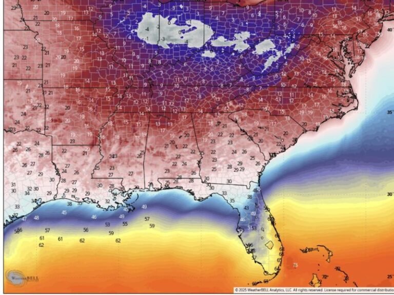
Meteorologists report that the incoming system will pull significantly colder air into western Oklahoma and the Texas Panhandle, where light snow is likely around Amarillo, Dumas, and Plainview. Meanwhile, central and northeastern Oklahoma may see patches of wintry mix, including sleet or wet snowflakes, especially in elevated areas.
Despite the dramatic change in weather, forecasters do not expect major travel impacts, thanks to relatively warm ground temperatures following the week’s unusual heat. Any frozen precipitation will mainly accumulate on grassy surfaces, rooftops, and elevated structures, with roadways staying mostly wet.
Light Accumulations Possible Across Select Areas
Forecast models highlight that light snow accumulations are possible in the Texas Panhandle, primarily west of I-27. The Amarillo region could see a dusting up to one inch in isolated pockets. While totals are not expected to be significant, the quick change in weather may catch some residents off guard given the region’s recent spring-like temperatures.
Farther east, from Muskogee to Bentonville, patchy wintry mix may develop briefly Sunday evening before transitioning back to rain as moisture shifts eastward. These areas are unlikely to experience measurable accumulation.
Why This Weather Shift Is Happening
The region has experienced several days of unseasonably warm temperatures, with some locations coming close to breaking heat records for late December. However, the strong cold front sliding through the Southern Plains will replace the warm air with a much colder and drier airmass, creating just enough lift and moisture overlap to support brief wintry precipitation.
Forecasters emphasize that this is not a significant winter storm, but rather a quick, localized event tied to the dynamic change in air masses.
What Residents Should Expect Sunday Night
Residents across Oklahoma and Texas should prepare for rapidly falling temperatures, gusty winds behind the front, and pockets of mixed precipitation that could briefly reduce visibility. Outdoor plans late Sunday may be affected, especially in areas expecting snow showers.
While travel impacts are not anticipated, meteorologists advise residents to stay aware as temperatures drop sharply after sunset. More updates will be provided by the Saluda Standard-Sentinel as the cold front continues to move across the region.