Oklahoma And Texas Brace For Isolated Strong Storms As Powerful Cold Front Pushes Into The Region Sunday
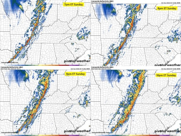
OKLAHOMA — A surge of much colder air moving into the Southern Plains on Sunday is expected to trigger isolated thunderstorms across southeastern Oklahoma and northeast Texas. While most storms are forecast to remain below severe limits, forecasters warn that one or two could intensify briefly on Sunday afternoon and early evening.
Cold Front Sparks Instability Ahead Of Sunday’s Arrival
Meteorologists report that increasing atmospheric instability will develop ahead of the front during the afternoon hours. That rise in storm energy will be focused in a corridor stretching from Dallas and Sherman in Texas up through Durant, Hugo, and the Choctaw Nation region in Oklahoma.
Warmer air in place early in the day will mix with the approaching cold front, creating just enough lift for scattered thunderstorms to form. These storms are expected to be isolated rather than widespread, but the environment will support brief pulses of stronger activity.
Isolated Thunderstorms Possible In a Narrow Zone
Forecast maps highlight a distinct zone where these storms are most likely to occur, including:
• Dallas–Fort Worth Metroplex
• Sherman and Plano, TX
• Durant and Hugo, OK
• Southeastern Oklahoma counties bordering Arkansas
In this highlighted area, storms may produce lightning, brief heavy rain, and gusty winds. Severe weather is not expected to be widespread, but forecasters cannot rule out a storm or two strengthening enough to produce stronger wind gusts or small hail before weakening.
Most Storms Expected To Stay Below Severe Levels
Despite the unstable air ahead of the front, the system does not have the ingredients needed for a large outbreak. Storms will develop quickly and fade just as fast, with very limited moisture available. The strongest storms will likely remain short-lived and isolated.
The cold front itself will sweep through rapidly Sunday evening, ending the storm threat and dropping temperatures sharply behind it. Much colder air will arrive overnight as winds shift, bringing a noticeable chill for the region early Monday morning.
Travel And Outdoor Plans May Be Briefly Interrupted
Residents with Sunday afternoon outdoor plans — including holiday travel — may experience brief weather interruptions as the front moves through. Lightning could cause short delays, and heavier showers may briefly reduce visibility on roads.
Forecasters urge residents to stay aware of quickly changing conditions, especially in southeast Oklahoma and northeast Texas where storm energy will be highest. For continuing updates on weather impacts across the South, stay connected with SaludaStandard-Sentinel.com.