Oklahoma and North Texas Forecast Unseasonably Warm Christmas With Highs Reaching the Mid to Upper 70s
OKLAHOMA CITY, OK — Forget the snow boots — Oklahoma and North Texas residents may need sunglasses and short sleeves this Christmas. Forecast maps show an unusually warm pattern settling across the region on December 25, with afternoon highs soaring into the mid to upper 70s, making for one of the warmest Christmas Days in recent memory.
According to the forecast shared by Half Moon Plumbing and regional meteorologists, temperatures will climb 10–20 degrees above normal, driven by strong southerly winds and a persistent ridge of high pressure.
Springlike Temperatures Across the Plains
Cities across the Southern Plains are expected to bask in sunny, dry, and breezy conditions throughout Christmas Day.
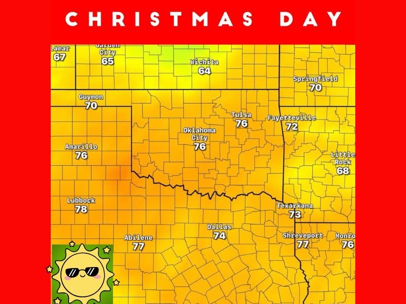
- Oklahoma City: 76°F
- Tulsa: 76°F
- Dallas, TX: 74°F
- Lubbock, TX: 78°F
- Abilene, TX: 77°F
- Amarillo, TX: 76°F
- Texarkana, AR: 73°F
- Shreveport, LA: 77°F
Meanwhile, farther north, areas like Wichita, Kansas (64°F) and Springfield, Missouri (70°F) will also see unseasonably mild weather, well above the December average.
“It’s shaping up to be a warm, breezy Christmas across the Southern Plains,” meteorologists said Tuesday. “Temperatures will easily climb into the 70s, with sunshine dominating most of the day. It’s more like April than December.”
No White Christmas for the Southern Plains
While some northern states are preparing for bitter cold and snow chances, the southern corridor from Oklahoma through Texas will see the opposite — a dry and warm stretch of weather that could challenge temperature records in some cities.
The last time Oklahoma City reached the mid-70s on Christmas Day was more than a decade ago. Average highs for this time of year typically sit around 50°F, making this forecast roughly 25 degrees above seasonal norms.
Why It’s So Warm
Meteorologists attribute the warm-up to a strong upper-level ridge over the central United States, steering cold Arctic air northward while drawing in mild air from the Gulf of Mexico.
“A combination of high pressure, light winds, and abundant sunshine will allow temperatures to spike quickly,” forecasters explained. “There’s no sign of winter air returning until after the holidays.”
What to Expect Christmas Weekend
The warmth will linger through much of the holiday weekend:
- Christmas Eve: Mostly sunny, highs near 70°F.
- Christmas Day: Sunny, breezy, and warm with highs between 74–78°F.
- December 26: Gradual cooling with highs returning to the upper 60s.
Winds could gust between 15–25 mph, adding to the springlike feel. With humidity levels remaining moderate, no rain is expected for holiday travel across Oklahoma or North Texas.
Travel and Outdoor Plans
The warm, dry conditions will provide excellent travel weather for those driving across the I-35 corridor, including Dallas, Oklahoma City, and Wichita. Residents planning outdoor gatherings or barbecues on Christmas Day will enjoy clear skies and comfortable warmth.
However, fire officials caution that gusty winds and dry vegetation could increase grass fire risks, particularly in western Oklahoma and the Texas Panhandle.
Looking Ahead
The extended forecast suggests a cool-down approaching late next week, but not before the region enjoys several days of mild, pleasant weather.
This year, it seems Santa might be trading his sleigh for sunglasses — and his red suit for a pair of swim trunks.
For more regional weather updates and travel forecasts, visit SaludaStandard-Sentinel.com.