Oklahoma and Kansas Could See Their First Snowfall of the Season Monday Evening
OKLAHOMA CITY, OKLAHOMA — A light winter system moving across the Southern Plains may bring the first measurable snow of the season to parts of Oklahoma and Kansas on Monday evening, according to the latest model data from regional forecasters.
While this won’t be a major snowstorm, meteorologists say residents across central and northeastern Oklahoma, as well as southern Kansas, could see a light dusting to around one inch of accumulation as colder air sweeps into the region.
Light Snow Expected Across the Plains
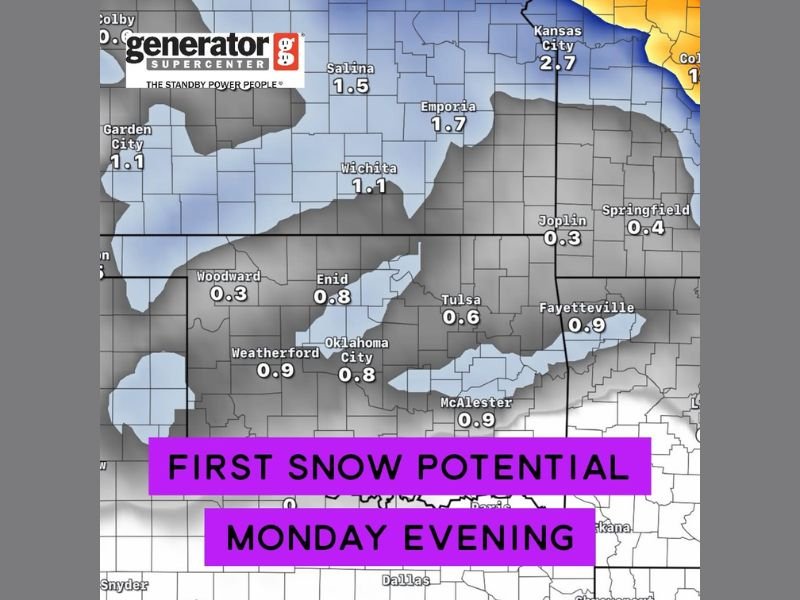
The forecast, powered by Generator Supercenter of Tulsa, shows snow showers developing late Monday afternoon, likely beginning in northwest Oklahoma before spreading eastward into Oklahoma City, Tulsa, and Wichita through the evening.
Preliminary accumulation projections suggest:
- Oklahoma City: Around 0.8–0.9 inches
- Tulsa: Around 0.6 inches
- McAlester: Around 0.9 inches
- Enid: Around 0.8 inches
- Wichita, Kansas: Around 1.1 inches
- Salina, Kansas: Around 1.5 inches
- Kansas City, Missouri: Up to 2.7 inches
Although the totals remain modest, this will mark the first measurable snow of the 2025–26 winter season for much of the region, following an unusually warm and dry November.
Forecast Confidence and Timing
Meteorologists caution that temperatures near freezing could result in a mix of rain and snow in southern Oklahoma, which might limit accumulation there. Areas further north, however, should stay cold enough for a brief period of light snow to develop and potentially coat grassy or elevated surfaces.
The best window for snowfall appears to be Monday evening through early Tuesday morning, before drier air filters in from the west.
“This won’t be a travel-impacting system for most, but it could be enough to create light slick spots overnight—especially on bridges and overpasses,” one forecaster explained Sunday. “It’s more of a symbolic start to the winter pattern than a disruptive event.”
Early Season Pattern Taking Shape
While this system will be relatively minor, it signals the beginning of a colder pattern shift across the Southern Plains heading into early December.
Meteorologists say another, stronger storm could develop later next week as Arctic air continues pushing southward, potentially opening the door for additional snow chances or freezing rain events by mid-December.
“We’re moving into that transitional period where brief snow events become more common,” the forecast team noted. “This one will mainly serve as a reminder that winter weather is back on the radar.”
Safety and Travel Tips
Even a light coating of snow can create slippery driving conditions, particularly during the early morning commute on Tuesday. Drivers are advised to:
- Reduce speed on elevated roads and bridges.
- Allow extra time for travel during early morning hours.
- Keep windshield wipers, washer fluid, and defrosters in working order.
No major travel disruptions are expected, but residents in northern Oklahoma and southern Kansas should prepare for colder temperatures dipping into the upper 20s to low 30s overnight.
Outlook
Following Monday’s system, conditions will remain seasonably cold through the week, with highs struggling to reach the upper 40s in central Oklahoma and low 40s in Kansas. Another reinforcing cold front is expected to arrive by next weekend, possibly bringing more winter-like conditions to the Plains.
Residents are encouraged to monitor local forecasts as updated snowfall data becomes available.
Stay tuned to SaludaStandard-Sentinel.com for continuing weather coverage and updated forecasts for Oklahoma, Kansas, and surrounding areas.