Oklahoma and Central U.S. Could See Surprise St. Patrick’s Day Cold Plunge With Temperatures Near Freezing Around March 16–17
OKLAHOMA — A stretch of mild early spring weather across the central United States could be interrupted by a brief but sharp cold plunge around St. Patrick’s Day, according to the latest long-range forecast guidance.
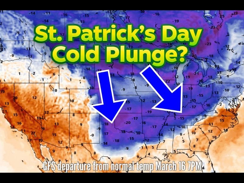
Recent runs from both the GFS and European weather models are suggesting that a pocket of significantly colder air could sweep southward across the central U.S. around March 16–17, potentially bringing overnight temperatures close to freezing in parts of Oklahoma and neighboring states.
While the forecast remains several days away and details are not yet locked in, meteorologists say it’s a scenario worth monitoring — especially for gardeners and anyone already preparing for spring planting.
Forecast Models Hint at Sudden Temperature Drop
The latest atmospheric projections show a large area of colder-than-normal air diving south across the central United States during the middle of March.
Temperature anomaly maps indicate the possibility of temperatures running well below seasonal averages, particularly across the Plains and portions of the Midwest.
If the pattern develops as currently projected, states including Oklahoma, Kansas, Missouri, and parts of Arkansas and Texas could experience a temporary surge of colder air.
Forecasters say overnight lows could approach freezing temperatures in some areas, creating concerns for sensitive plants that may have already begun emerging during the early spring warmth.
Timing Could Coincide With St. Patrick’s Day Weekend
What makes this potential cold surge notable is its timing around the St. Patrick’s Day period, when many residents are expecting typical spring-like weather.
The projected cold shot is expected to be brief but noticeable, arriving after a period of warmer conditions that may give many areas a false sense that winter is fully over.
Meteorologists often refer to this pattern as “false spring,” when early warmth encourages plant growth before a late-season cold snap arrives.
Gardeners May Need to Watch Temperatures Closely
Because the forecast suggests overnight lows possibly dipping near freezing, experts say gardeners across parts of the central Plains should keep an eye on upcoming forecasts.
Newly planted vegetation, early blooms, and sensitive crops can be vulnerable to even short-lived cold snaps during March. However, forecasters stress that the event is still several days away, and exact temperatures and coverage could change as newer model runs refine the forecast.
Forecast Still Uncertain but Worth Monitoring
Meteorologists caution that long-range forecasts often evolve, meaning the intensity or track of the cold air mass could shift in the coming days. Still, the signal appearing in multiple forecast models suggests that a notable temperature swing is possible across the central United States around mid-March.
If the colder air does materialize, it would serve as a reminder that winter weather patterns can still influence the region even as spring approaches. Residents across the Plains and central U.S. are encouraged to continue monitoring forecasts in the coming days.
Stay with SaludaStandard-Sentinel.com for updates as meteorologists track potential late-season cold surges and other developing weather patterns across the United States.