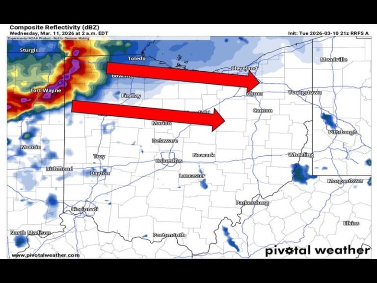
Ohio Snow Threat Builds Wednesday–Thursday as Lake-Enhanced Bands and Uncertain Storm Phasing Could Drive Totals From Dusting to Over 6 Inches
OHIO — Forecasters are closely monitoring a developing snow setup from Wednesday afternoon through Thursday evening, as a combination of lake-enhanced snowfall and uncertain storm phasing creates a wide range of possible outcomes across northern and central Ohio.
Timing: Wednesday Afternoon Through Thursday Evening
Current guidance shows snow developing Wednesday afternoon and continuing into Thursday evening, with impacts increasing overnight Wednesday into early Thursday. While some areas may see only light accumulations, others — especially closer to Lake Erie — could experience more persistent snowfall. The biggest challenge for forecasters remains how two separate pieces of atmospheric energy interact as the system evolves.
Why the Forecast Is Uncertain: The Phasing Question
At the heart of the forecast uncertainty is whether two weather disturbances “phase” together. If these systems link up at the right time and location, snowfall rates and totals could increase rapidly.
If phasing occurs, forecasters warn that widespread, more significant snowfall could develop. If it does not, the result would likely be a lighter, more modest snow event, with totals staying on the lower end of projections. Right now, the atmosphere has not committed either way.
Lake-Enhanced Snow Is the Most Reliable Factor
One part of the forecast carrying higher confidence is lake-enhanced snowfall, particularly for northern Ohio. Persistent north-northwest winds from Wednesday afternoon into Thursday are expected to tap moisture from Lake Erie, and potentially even establish a Lake Huron connection. If a narrow snow band sets up and stalls, localized totals could climb quickly, with some spots potentially flirting with near a foot of snow under a persistent band.
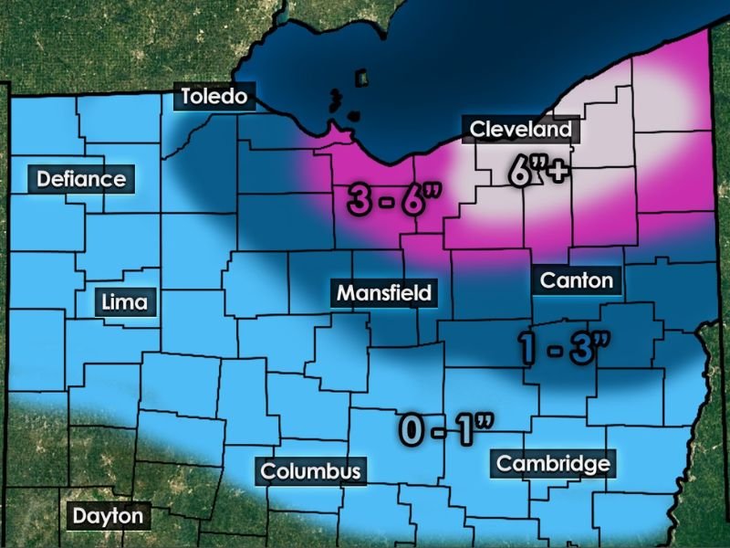
Expected Snow Ranges by Region
Early projections suggest a sharp snowfall gradient across the state. Areas near the Lake Erie shoreline — including parts of Cleveland and surrounding counties — could see 3 to 6 inches or more, while locations farther south toward Mansfield, Canton, and Columbus may see totals closer to 1 to 3 inches or less, depending on band placement. Small shifts in wind direction could dramatically change who sees heavier snow and who does not.
What Residents Should Prepare For
Forecasters caution that snow totals may change significantly as models refine the storm’s evolution. Even modest accumulations could still impact the Thursday morning commute, especially in lake-effect zones where snow can fall quickly. Drivers should be prepared for rapidly changing road conditions, particularly overnight and early Thursday.
Bottom Line
This is a classic Ohio winter setup where confidence in snow existing is high, but confidence in exact amounts remains low. Experience with similar patterns suggests keeping expectations flexible and staying alert for forecast updates over the next 24 to 36 hours.
Are you hoping for more snow — or less — this time around? Share what you’re seeing in your area and how you’re preparing by joining the conversation at SaludaStandard-Sentinel.com.