Northern Ohio Including Cleveland, Toledo and Akron Could See Severe Storms Saturday as Early Signals Point to Unstable Setup With Multiple Threats
OHIO — An early alert has been issued for northern Ohio as forecasters track a developing setup that could bring severe storms to the region by Saturday afternoon and evening.
While the system is still several days out, consistent model trends are now pointing toward an environment capable of producing strong storms across cities like Cleveland, Toledo, Akron, and surrounding areas.
Early Signals Show Increasing Severe Weather Potential
Meteorological data indicates a growing signal for severe weather as multiple ingredients begin to align. Forecast models highlight a combination of warm, moisture-rich air, rising instability, and an approaching cold front, all of which are key factors in storm development.
This setup, if it continues to hold, could support multiple modes of severe weather, meaning storms may not only bring heavy rain but also damaging winds, hail, and possibly tornado activity. Forecasters stress that while this is still an early outlook, the consistency in model guidance is becoming harder to ignore.
Storm Development Expected Saturday Afternoon Into Evening
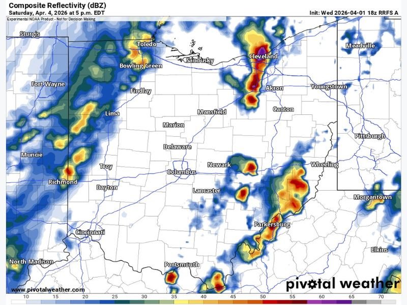
Current projections suggest that storms could begin developing Saturday afternoon, with activity increasing into the evening hours across much of northern Ohio.
Radar simulation data shows clusters of storms forming near areas such as Toledo and Cleveland, with additional activity extending south and east toward Akron and even into parts of eastern Ohio. These storms appear capable of organizing into stronger cells, particularly if instability continues to build during the day.
Key Cities in Potential Impact Zone
The areas most likely to be impacted based on current trends include:
- Cleveland and surrounding Lake Erie shoreline communities
- Toledo and northwest Ohio
- Akron and northeast Ohio
- Portions of central and eastern Ohio, including areas near Columbus and toward the Ohio River Valley
While not every location will see severe weather, the potential coverage suggests a broad regional threat rather than isolated activity.
All Severe Weather Modes Could Be Possible
If the setup verifies, forecasters warn that the region could see:
- Damaging wind gusts from stronger storm cores
- Large hail, particularly with discrete storm development
- Isolated tornado potential, depending on how storms organize
The combination of atmospheric ingredients raises concern for a more active severe weather day than typically seen this early in April.
Still an Early Outlook but Trends Worth Watching
At approximately three to four days out, uncertainty remains regarding exact timing, storm intensity, and coverage. However, forecasters note that when early signals repeatedly show the same pattern, it often indicates a legitimate setup worth monitoring closely. Additional updates, including more refined risk areas and timing details, are expected as newer data becomes available.
Residents Advised to Stay Weather-Aware
Residents across northern Ohio are encouraged to stay alert and begin preparing for the possibility of severe weather this weekend. Early awareness can make a significant difference if conditions intensify.
Officials recommend monitoring forecasts regularly and ensuring access to weather alerts as Saturday approaches. As this developing situation continues to evolve, readers can stay updated and share local conditions with ongoing coverage at SaludaStandard-Sentinel.com.