Northern Indiana Hit by Intensifying Lake Effect Snow With Whiteout Conditions, 2-Inch Per Hour Rates and Dangerous Black Ice Forming
INDIANA — Lake effect snow is rapidly intensifying across northern Indiana this evening, bringing bursts of heavy snowfall, dangerous travel conditions, and the growing risk of whiteout visibility in several areas.
Forecasters warn that snowfall rates could reach 1 to 2 inches per hour at times, especially near major travel corridors, creating rapidly deteriorating conditions for drivers.
Heavy Snow Bands Target Northern Indiana Communities
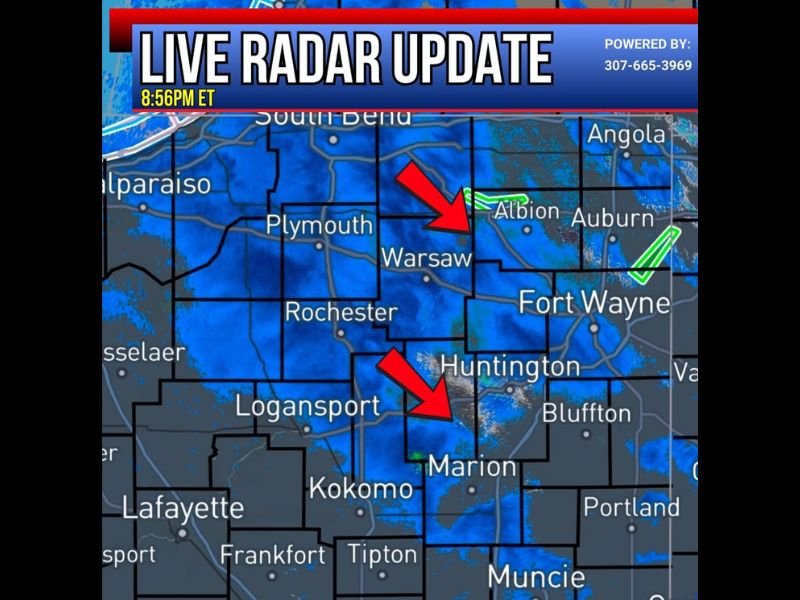
Radar imagery shows concentrated snow bands moving across parts of northern Indiana, including areas near Warsaw, Plymouth, and Marion. These lake effect bands are capable of producing sudden and intense snowfall over localized areas.
Communities within these bands may experience quick accumulations, with visibility dropping sharply as snow intensity increases. Areas just outside the bands may see lighter snowfall, highlighting the uneven nature of lake effect events.
Meteorologists note that these narrow but powerful snow bands can shift slightly, bringing sudden changes in conditions from one location to another.
Whiteout Conditions Possible With Strong Winds
In addition to heavy snowfall, gusty winds are contributing to blowing snow and reduced visibility. This combination raises the risk of whiteout conditions, where drivers may struggle to see even a short distance ahead.
Officials caution that these conditions can develop quickly, especially at night, making travel extremely hazardous. Sudden drops in visibility are one of the most dangerous aspects of lake effect snow events. Drivers are urged to slow down and remain alert as conditions can change within minutes.
Black Ice Creating Additional Road Hazards
Beyond the falling snow, black ice is forming on many roadways across northern Indiana. This nearly invisible layer of ice can make roads extremely slick, even in areas where snow accumulation appears minimal.
Bridges, overpasses, and untreated roads are especially vulnerable, increasing the risk of accidents. Combined with ongoing snowfall, these icy conditions are making travel particularly dangerous. Authorities are advising motorists to use extreme caution and avoid unnecessary travel if possible.
Hazardous Travel Expected to Continue Overnight
The combination of heavy snowfall rates, blowing snow, and icy roads is expected to persist through the night. Conditions may remain hazardous into the early morning hours, particularly along routes near the Indiana Toll Road where snowfall rates are expected to be highest.
Plow crews are working to keep major roadways clear, but rapidly accumulating snow may limit their effectiveness during peak snowfall periods. Residents should prepare for slower travel, potential delays, and rapidly changing conditions overnight.
Residents Urged to Stay Alert During Ongoing Snow Event
Officials are emphasizing the importance of staying informed and adjusting travel plans as conditions worsen. Lake effect snow events are known for their intensity and unpredictability, making awareness critical.
With whiteout conditions possible and black ice forming across the region, even short trips can become dangerous. If you are experiencing heavy snow or hazardous road conditions, share your updates with us and stay informed with the latest coverage on SaludaStandard-Sentinel.com.