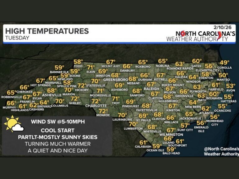
North Georgia Braces for Rare Monday Weather Swing With Morning Thunderstorms Turning to Snow Showers by Afternoon
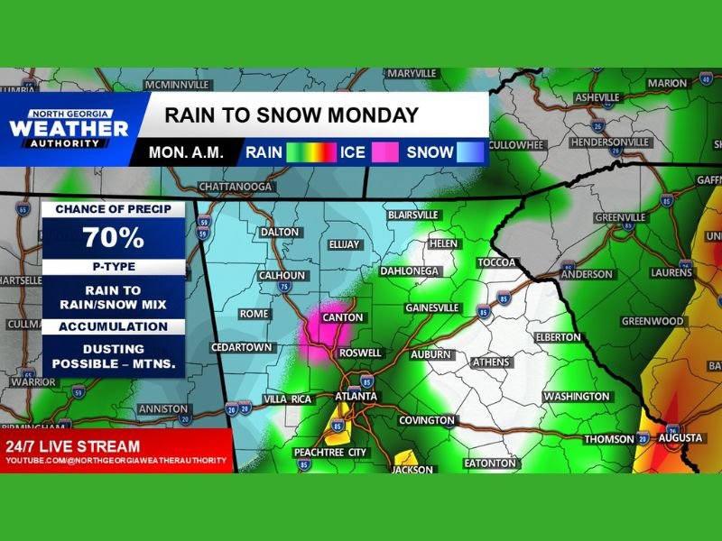
NORTH GEORGIA — A dramatic weather shift is expected across the region Monday as thunderstorms early in the day could transition into snow showers by the afternoon. Meteorologists say a powerful cold front moving through the Southeast will bring rapidly falling temperatures and enough moisture to allow a brief changeover from rain to snow in parts of the state.
Forecasters describe Monday as a “wild weather day” for north Georgia, with multiple weather types expected within just a few hours as colder air rushes into the region behind the front.
Early Morning Thunderstorms Expected Across North Georgia
Weather models suggest thunderstorms may develop across north Georgia early Monday morning as warm, unstable air remains in place ahead of the incoming cold front.
Cities including Atlanta, Gainesville, Dahlonega, and surrounding communities could experience periods of rain and thunderstorms during the morning hours. Some storms could produce brief heavy rainfall and gusty winds as the front begins moving through the region.
Meteorologists say this early round of precipitation will primarily fall as rain because temperatures will still be relatively mild during the initial stages of the system.
Cold Air Rushes In Behind the Front
Conditions are expected to change quickly once the cold front moves through the region later in the day. As colder air surges southward behind the front, temperatures across north Georgia could drop rapidly. This change will allow rain to mix with snow and eventually transition into scattered snow showers in some areas. The overlap of lingering moisture and incoming cold air is the key factor that could allow snow to develop even after earlier thunderstorms.
Snow Showers Possible in Higher Elevations
Forecasters say the best chance for snow will occur in higher elevations and mountainous areas of north Georgia. Communities around Blairsville, Ellijay, and other mountain locations may see brief snow showers later in the day as colder air settles across the region.
While significant snowfall is not expected, meteorologists say a light dusting could be possible in the mountains if snow showers become organized. Lower elevations across the Atlanta metro area and surrounding communities may mainly see rain transitioning to a rain-and-snow mix with little or no accumulation.
Rapid Weather Changes Could Surprise Residents
The combination of thunderstorms followed by snow showers highlights how quickly weather conditions can change during late winter and early spring. These types of setups occur when a strong cold front pushes into warm, moisture-rich air already present over the Southeast. Once the front passes, temperatures can drop quickly enough to support winter precipitation even after earlier storms.
Because of the rapid shift in weather conditions, residents may experience multiple types of precipitation throughout the day. Drivers in mountain areas should remain cautious if temperatures drop quickly, as wet roads could briefly become slick if snow showers develop.
Forecasters Monitoring the Situation Closely
Meteorologists will continue monitoring the strength of the incoming cold front and how much moisture remains in the atmosphere behind it. If the cold air arrives faster or moisture lingers longer than expected, snow showers could become slightly more widespread across higher elevations.
However, at this time forecasters say any snowfall should remain light and short-lived. Residents across north Georgia are encouraged to stay updated on local weather forecasts and prepare for rapidly changing conditions throughout Monday. If weather conditions change in your community, share your observations with the newsroom at SaludaStandard-Sentinel.com to help keep readers informed about developing weather across the region.