North Carolina Warm-Up to the 40s Could Bring Rain Tuesday Night, Then a Late Wet-Snow Mix Near Raleigh and Winston-Salem Into Early Thursday
NORTH CAROLINA — A brief warm-up is expected to push temperatures back into the 40s by Tuesday, but a midweek system could follow with light rain Tuesday night into Wednesday afternoon, then a potential wet-snow mix Wednesday evening into very early Thursday, according to the latest forecast messaging tied to the updated model display.
Tuesday Brings a Break: Temperatures Climb Back Into the 40s
The forecast outlook emphasizes a “pretty nice warmup” into Tuesday, with much of the state rebounding into the 40s. That kind of temperature recovery matters because it reduces the odds of immediate winter impacts during the day, and it supports a mostly rain-driven event as moisture arrives later.
For many areas that have been dealing with repeated cold snaps, the warmer Tuesday setup is the short-term relief before the next round of unsettled weather moves in.
Rain Likely Tuesday Night Through Wednesday Afternoon
Scattered light rain is possible beginning Tuesday night and continuing into Wednesday afternoon. The messaging describes the rain as mostly light and not a major soaking event, suggesting intermittent showers rather than a long-lasting heavy rain shield.
This phase of the system is expected to be primarily liquid precipitation because temperatures are projected to remain mild enough for rain across much of the state during the daytime Wednesday period.
Wednesday Evening to Early Thursday: Where Wet Snow Could Mix In
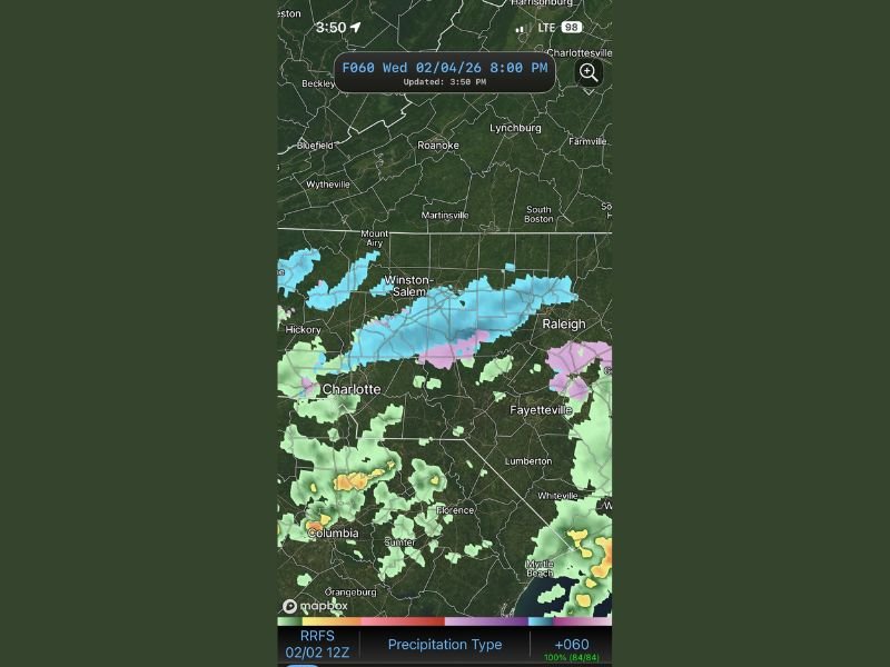
The more uncertain piece comes later: the outlook notes that some wet snow could mix in with rain from Wednesday evening into very early Thursday. The map snapshot shown is timestamped Wednesday 02/04/26 at 8:00 PM, and it depicts a band of wintry precipitation (shaded in colder tones) stretching across parts of the central and northern Piedmont.
The highlighted area includes the corridor near Winston-Salem and extends toward areas west and north of Raleigh, with a transition zone where mixed precipitation appears possible. Farther south, including around Charlotte, the depiction trends more toward rain.
Why Impacts Are Expected to Be Light Even If Snow Shows Up
Even if wet snow mixes in, the forecast messaging stresses that amounts and impacts would likely be light. That is typically because temperatures during these setups are marginal, meaning snow can fall but struggles to accumulate quickly—especially on paved surfaces that have been warmed by earlier mild conditions.
If any accumulation does occur, it usually favors grassy or elevated surfaces and can be brief, especially if precipitation ends quickly or temperatures rise again after sunrise.
What Residents Should Watch Closely
The key word in this forecast is possibility. This is not being framed as a winter storm warning scenario—more of a “keep an eye on it” setup where small timing shifts decide whether areas see only rain, a brief mix, or a short-lived period of wet snow.
Residents should pay closest attention to:
- Whether colder air arrives faster Wednesday evening
- How long precipitation lingers overnight
- Which areas fall along the rain/snow line near the Triad-to-Raleigh corridor
Bottom Line: Mild Start, Unsettled Finish
North Carolina’s midweek forecast points to a mild Tuesday in the 40s, then a mainly rain event Tuesday night through Wednesday afternoon, followed by a late potential for wet snow mixing in Wednesday night into early Thursday—especially near and north of the Winston-Salem to Raleigh corridor. The current expectation is for limited impacts, but it’s still worth tracking as new updates come in.
Are you seeing rain on your app or a snow icon popping up for Wednesday night in your area? Tell us what your forecast looks like and keep following updates at SaludaStandard-Sentinel.com.